The US-Mexican Border: The Third Country
The US – Mexican border has been described as a Third Country that is 2,000 miles long and 20 miles wide.
By Ken Alexander*
HAVANA TIMES – Life along the border has changed as it has become more militarized and the US’s history of racist rhetoric takes its toll on its southern neighbors.
“We need milk.“
“It is late. I think the store here in Tijuana may be closed.”
“OK, then I will go to the store in the US, since it is open later. I’ll be back in twenty minutes.”
Before 9/11 life for Mexicans living south of the US-Mexican border played out with little need to consider the boundary between the two countries. A simple decision such as where to pick up milk, either on the US or Mexican side of the border, was made based upon the time of day, traffic conditions or which stores were open late.
Hiram Bellozo, who has lived in Tijuana his whole life, says “Everyone I knew growing up as a child had a visa that allowed them to travel up to 25 miles into the US, for school, work, or shopping. The border crossing was a minor inconvenience. The border was friendly. We were friendly with the border guards. It was no big deal.”
Today, tens of thousands of Mexicans still cross the border on a daily basis for school and work. Around 3:30 in the afternoon, in Nogales, Mexico you can watch as a steady stream of Mexican children return home across the border after a day of school in Nogales, Arizona.

Tijuana, Mexico (referred to as TJ by locals in both countries) feels like it is part of the greater San Diego metro area. Thousands of people live in Tijuana and commute daily to jobs in the US. I was in Tijuana in 2018 photographing the Central Americans in the migrant camps. For two weeks my taxi driver, Hiram, drove me around TJ in his Mexican cab. When it was time to leave he simply drove me across the border up to San Diego. He said he would probably pick up a fare in San Diego for the way back home.
In San Diego, my Uber driver was a US citizen born in Atlanta, Georgia. At night he went back to Tijuana, Mexico where he lived because it was cheaper. He does that commute 6 or 7 days a week. Groceries and clothes are cheaper in the U.S, but rent and services are cheaper in Mexico.
However, today there is no friendly border guard. As you cross back into the United States you are greeted with layers of barbed wire, heavily armed border patrol agents, drug-sniffing dogs, and sophisticated surveillance equipment.
A driver heading into the U.S can wait in line between two and six hours. And, once you reach the border crossing your car will be X-rayed, your documents electronically scanned and your car possibly disassembled if there is suspicion that you are transporting drugs. It is an incredibly hostile place.
The typical US view of ‘the border’ is perhaps only what is seen on the news when there is a border incident. Images of migrants running from tear gas, migrants being dumped at bus stations in El Paso and other sensationalized images.
The reality is that the Border, and the land and people on both sides, is an amazingly complex and diverse place more aptly experienced as a third country, as writer Tom Miller describes it, than just the boundary between two nations.
A Brief History of the Border
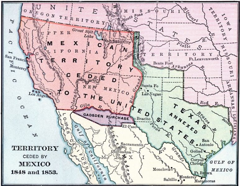
The border between the United States and Mexico is the busiest land border in the world and one of the longest. It covers almost 2,000 miles stretching from the Pacific Ocean to the Gulf of Mexico.
It lies adjacent to four US States (California, Arizona, New Mexico, Texas) and six Mexican States (Baja California, Sonora, Chihuahua, Coahuila, Nuevo León, Tamaulipas).
1,240 miles of the border, over 60%, consists of The Rio Grande and parts of the Colorado River. The remaining 750 miles of land border starts at the Pacific Ocean and crosses vast deserts and tall mountains.
The current border was established in the mid 1800’s. The US annexed Texas in 1845. After the Mexican-American war in 1848 Mexico ceded California and most of what is now Arizona and New Mexico. The 1848 Treaty of Guadalupe established the Rio Grande as the official international border. And the Gadsden Purchase in 1853 extended the borders of Arizona and New Mexico southwards to where they are today.
Border Fences

It was not until after 1910, during the Mexican Revolution and WWI, that both countries erected the first fences in an attempt to restrict cross-border migration. These appear to have disappeared by 1920.
In the 1940’s cattle fencing was erected near Organ Pipe Cactus National Monument, not to keep people out, but to keep Mexican cattle from overgrazing U.S lands and infecting US livestock.
But in the 1990’s, George H. W. Bush ordered a border wall built starting at the Pacific Ocean and extending inland 66 miles. This became known as the San Diego sector. The general consensus by Congress years later was that this wall was ineffective in accomplishing anything. So it is with walls.
Bill Clinton authorized a 14 mile extension to the San Diego sector. Another 670 miles of border fencing was ordered by George W. Bush in 2006, much of it in Texas. However, this effort would have required waiving 36 environmental regulations. Lawsuits by environmental groups delayed and limited the project. By 2009, 450 miles of that border wall were eventually erected.
As of a few years ago the US had erected over 650 miles of permanent border fences. About half of that fencing is designed to stop pedestrians from crossing while the other half is only meant to stop vehicles. Most of the 48 ports of entry along the border are fortified with tall pedestrian fencing in both directions, eventually transitioning to vehicle barriers as the wall leaves the urban areas.
More Walls
Most experts agree that the proposed wall being debated now in the US would not be effective and not achieve the goal of ‘border security’. Many agree that the passage of a funding bill for the wall would only serve the political needs of a single man and those who ride on his coattails.
But, any expansion of the border wall has serious environment implications and logistical challenges.

According to the Americas Society, one logistical challenge to the construction of such a wall is the incredibly varied nature of the terrain along the nearly 2,000 miles of the border. To reinforce the fence starting at the Pacific Ocean, construction materials would have to contend with corrosive salt spray, changing tides, and heavy winds.
Farther east in inland California lie the Algodones Dunes, also known as the Imperial Dunes—the largest sand dune ecosystem in the United States. The current seven-mile floating fence here is specifically engineered to work with the shifting sands. The border territory farther east in Arizona and New Mexico is so mountainous—Coronado National Forest is home to several 9,000-foot peaks—it has been described as ‘unfenceable’.
Around 75 miles of the border in Arizona is part of the Tohono O’odham Indian reservation; the third largest reservation in the US. The original Tohono O’odham territory was bifurcated by the Gadsden Purchase. Tribe members still live on both sides of the border and freely cross between the two sections as they consider the entirety of the territory their ancestral lands.
Today
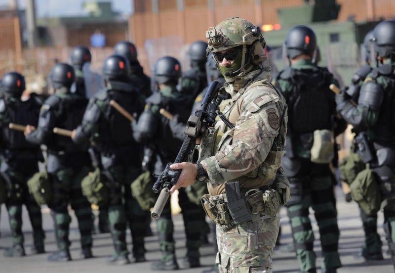
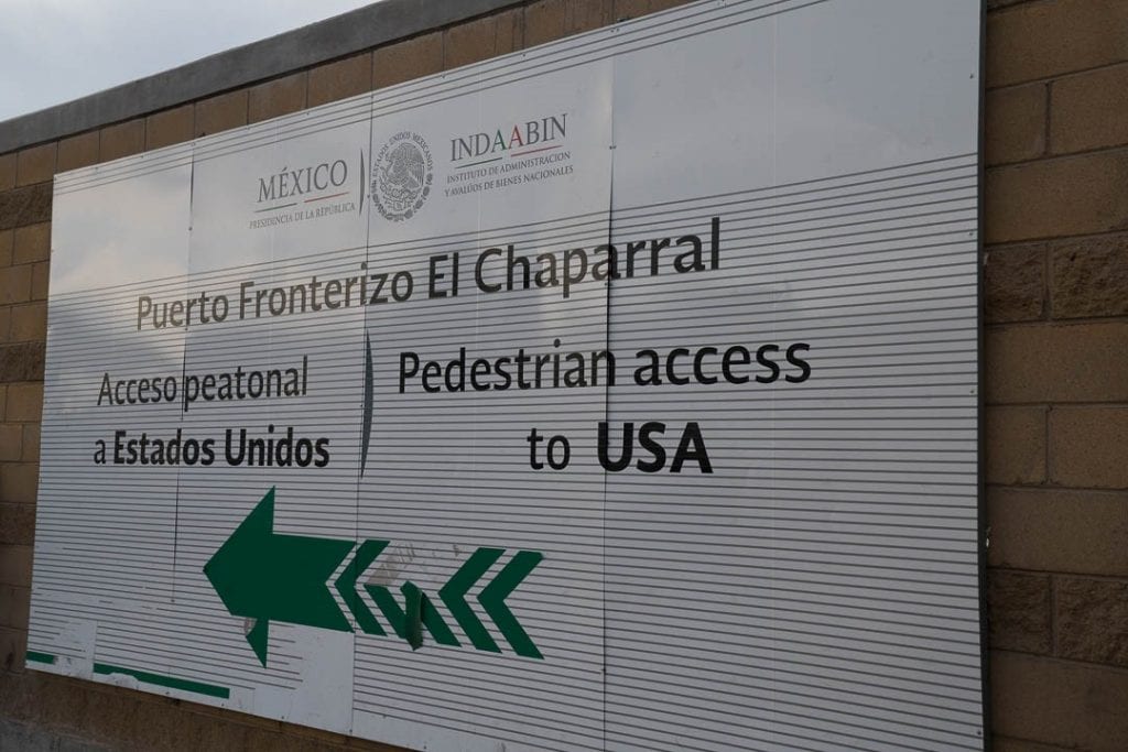
Life is different today along the border, particularly in Tijuana – the busiest port of entry between the U.S and Mexico. Tourism has slowed tremendously because of the fear of violence related to the migrants. Xenophobia has taken over as the locals blame the Central Americans for the problem. Recent threats of closing the border have paralyzed parts of the economy. Border agents with machine guns are visible everywhere.
Recently I stood in line at the pedestrian crossing at San Ysidro, California on my way into Tijuana. There are two lines; one for Mexican nationals and one for foreigners. As hundreds of Mexicans passed through the border returning home with shopping bags and school backpacks, I realized that I was the only person in the foreigner line. “People from the US have stopped coming.” is what I heard from the local shop keepers, taxi drivers and restaurant owners that I talked to in Tijuana. “Look. It is a Saturday night and there are only Mexicans in the clubs and restaurants.”
Life for those living just south of the border has changed. The wall of US xenophobia and racism is quite visible. And there is no question about where to buy that gallon of milk.
I believe you and the racists have this in common, your words divide.
Few are those who work for peace. Rise up peacemakers of the world!