Cuba: Varadero Resorts Endangerd by Hurricane Irma
By Circles Robinson
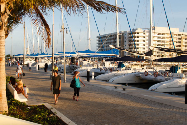
HAVANA TIMES – The latest projections for the path of Hurricane Irma show Varadero, Cuba’s leading beach resort area in the province of Matanzas, in danger of receiving the full force or close to it.
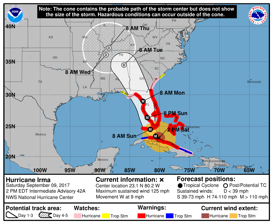
At 2:00 p.m. Cuban time (EDT), the National Hurricane Center in Miami located the center of Irma at only 65 miles (100 kms) east of Varadero. The maximum sustained winds are currently 125 mph (205 km/h) with stronger gusts.
The storm has slowed it movement considerably and is now moving west at 9 mph (15 km/h). The slowdown is bad news for the affected areas because it could mean increased rainfall. The possible damage in Varadero depends mostly on when Irma takes an expected turn north en route to Florida.
The longer Irma continues moving west before veering north the greater danger to Varadero, Matanzas, Mayabeque, Artemisa and Havana.
The Cuban capital and these other western provinces are now on hurricane alert and evacuations are taking place in low lying areas.
Cuba has much experience in safeguarding lives during the passing of hurricanes, but the debilitated housing stock throughout the country and especially in Havana put the country at great risk. Recovery from past hurricanes is still underway, with the housing and building material needs way below demand.
The following is the complete advisory bulletin from the National Hurricane Center issued at 2:00 PM EDT.
Hurricane Irma Advisory
…IRMA LINGERING OVER THE NORTH COAST OF CUBA…
…MAJOR HURRICANE FORCE WINDS EXPECTED OVER THE FLORIDA KEYS AT
DAYBREAK…
SUMMARY OF 2:00 PM EDT…1800 UTC…INFORMATION
———————————————-
LOCATION…23.1N 80.2W
ABOUT 65 MI…100 KM E OF VARADERO CUBA
ABOUT 145 MI…235 KM SE OF KEY WEST FLORIDA
MAXIMUM SUSTAINED WINDS…125 MPH…205 KM/H
PRESENT MOVEMENT…W OR 280 DEGREES AT 9 MPH…15 KM/H
MINIMUM CENTRAL PRESSURE…941 MB…27.79 INCHES
WATCHES AND WARNINGS
——————–
SUMMARY OF WATCHES AND WARNINGS IN EFFECT:
A Storm Surge Warning is in effect for…
* Volusia/Brevard County line southward around the Florida
peninsula to the Suwanee River
* Florida Keys
* Tampa Bay
A Storm Surge Watch is in effect for…
* North of the Volusia/Brevard County line to the Isle of Palms,
South Carolina
* North of the Suwanee River to Ochlockonee River
A Hurricane Warning is in effect for…
* Fernandina Beach southward around the Florida peninsula to
the Aucilla River
* Florida Keys
* Lake Okeechobee
* Florida Bay
* Cuban provinces of Camaguey, Ciego de Avila, Sancti Spiritus,
Villa Clara, Matanzas, and Havana
* Andros Island, Bimini and Grand Bahama
A Hurricane Watch is in effect for…
* North of Fernandina Beach to Edisto Beach
* West of the Aucilla River to Indian Pass
* Cuban provinces of Holguin and Las Tunas
A Tropical Storm Warning is in effect for…
* Cuban provinces of Holguin, Las Tunas
A Tropical Storm Watch is in effect for…
* North of Edisto Beach to South Santee River
* West of Indian Pass to the Okaloosa/Walton County Line
A Storm Surge Warning means there is a danger of life-threatening
inundation, from rising water moving inland from the coastline,
during the next 36 hours in the indicated locations. For a
depiction of areas at risk, please see the National Weather
Service Storm Surge Watch/Warning Graphic, available at
hurricanes.gov. This is a life-threatening situation. Persons
located within these areas should take all necessary actions to
protect life and property from rising water and the potential for
other dangerous conditions. Promptly follow evacuation and other
instructions from local officials.
A Storm Surge Watch means there is a possibility of life-
threatening inundation, from rising water moving inland from the
coastline, in the indicated locations during the next 48 hours.
For a depiction of areas at risk, please see the National Weather
Service Storm Surge Watch/Warning Graphic, available at
hurricanes.gov.
A Hurricane Warning means that hurricane conditions are expected
somewhere within the warning area. Preparations to protect life and
property should be rushed to completion.
A Hurricane Watch means that hurricane conditions are possible
within the watch area. A watch is typically issued 48 hours
before the anticipated first occurrence of tropical-storm-force
winds, conditions that make outside preparations difficult or
dangerous.
A Tropical Storm Warning means that tropical storm conditions are
expected somewhere within the warning area.
A Tropical Storm Watch means that tropical storm conditions are
possible within the watch area, generally within 48 hours.
Interests elsewhere in Cuba and the southeastern United States
should monitor the progress of Irma.
For storm information specific to your area in the United States,
including possible inland watches and warnings, please monitor
products issued by your local National Weather Service forecast
office. For storm information specific to your area outside the
United States, please monitor products issued by your national
meteorological service.
DISCUSSION AND 48-HOUR OUTLOOK
——————————
At 200 PM EDT (1800 UTC), the eye of Hurricane Irma was located by
radar near latitude 23.1 North, longitude 80.2 West. Irma is moving
just north of due west along the north coast of Cuba at near 9 mph
(15 km/h). A northwest motion is expected to begin later today with
a turn toward the north-northwest on Sunday. On the forecast track,
the core of Irma will continue to move near or over the north coast
of Cuba this afternoon, and will reach the Florida Keys Sunday
morning. The hurricane is expected to move along or near the
southwest coast of Florida Sunday afternoon.
Maximum sustained winds are near 125 mph (205 km/h) with higher
gusts. Irma is a category 3 hurricane on the Saffir-Simpson
Hurricane Wind Scale. Irma is forecast to restrengthen once it
moves away from Cuba, and Irma is expected to remain a powerful
hurricane as it approaches Florida. A NOAA plane is airborne en
route to investigate Irma.
Hurricane-force winds extend outward up to 70 miles (110 km) from
the center and tropical-storm-force winds extend outward up to 195
miles (315 km).
The estimated minimum central pressure is 941 mb (27.79 inches).
HAZARDS AFFECTING LAND
———————-
STORM SURGE: The combination of a dangerous storm surge and the
tide will cause normally dry areas near the coast to be flooded by
rising waters moving inland from the shoreline. The water is
expected to reach the following HEIGHTS ABOVE GROUND if the peak
surge occurs at the time of high tide…
Cape Sable to Captiva…10 to 15 ft
Captiva to Ana Maria Island…6 to 10 ft
Card Sound Bridge through Cape Sable, including the Florida
Keys…5 to 10 ft
Ana Maria Island to Clearwater Beach, including Tampa Bay…5 to 8
ft
North Miami Beach to Card Sound Bridge, including Biscayne Bay…4
to 6 ft
Isle of Palms, South Carolina to Fernandina Beach…4 to 6 ft
Clearwater Beach to Ochlockonee River…4 to 6 ft
Fernandina Beach to North Miami Beach…2 to 4 ft
The deepest water will occur along the immediate coast in areas of
onshore winds, where the surge will be accompanied by large and
destructive waves. Surge-related flooding depends on the relative
timing of the surge and the tidal cycle, and can vary greatly over
short distances. For information specific to your area, please see
products issued by your local National Weather Service forecast
office.
The combination of a life-threatening storm surge and large breaking
waves will raise water levels ABOVE NORMAL TIDE LEVELS by the
following amounts within the hurricane warning area near and to the
north of the center of Irma. Near the coast, the surge will be
accompanied by large and destructive waves.
Northwestern Bahamas…3 to 6 ft
Northern coast of Cuba in the warning area…5 to 10 ft
WIND: Hurricane conditions are expected to continue within the
hurricane warning area along the north coast of Cuba through today.
Hurricane conditions are expected in portions of the northwestern
Bahamas today, and in portions of the Florida peninsula and the
Florida Keys tonight and Sunday.
Hurricane and tropical storm conditions are possible within the
watch area on Sunday.
RAINFALL: Irma is expected to produce the following rain
accumulations through Wednesday:
Northern Cuba…10 to 15 inches, isolated 20 inches.
Southern Cuba…5 to 10 inches, isolated 15 inches.
Western Bahamas…3 to 6 inches, isolated 10 inches.
The Florida Keys…10 to 20 inches, isolated 25 inches.
The Florida peninsula and southeast Georgia…8 to 15 inches,
isolated 20 inches.
The eastern Florida Panhandle…3 to 6 inches, isolated 8 inches.
Rest of eastern Georgia, western South Carolina, and western North
Carolina…4 to 8 inches.
Western Georgia, eastern and northern Alabama, and southern
Tennessee…2 to 5 inches.
In all areas this rainfall may cause life-threatening flash floods
and, in some areas, mudslides.
TORNADOES: A few tornadoes are possible today and tonight over
southern Florida.
SURF: Swells generated by Irma are affecting the southeastern
Bahamas, the Turks and Caicos Islands and the southeast coast of the
United States today. These swells are likely to cause life-
threatening surf and rip current conditions. Please consult
products from your local weather office.
On Sunday morning José Miguel Vázquez, a journalist for
Radio 26, reported that the initial evaluations have begun to measure the damage in the province of Matanzas. He notes that there is serious damage in some areas including the Varadero. He noted that the entire province is without electricity, only the generators are working at hospitals, water pumping stations and some other basic services.
At 7:40 p.m. Ivis Fernandez, the head of the Ministry of Tourism for Matanzas, told the official Granma newspaper that there are 14,500 foreign tourists in Varadero and 1,214 national tourists. She said that all the customers are in safe zones, highlighting that they are calm and thankful. The official added that there are 4,100 workers attending to the tourists needs and safety.