Graham Sowa
HAVANA TIMES — During a recent excursion to The Pan de Guajaibón, western Cuba’s highest peak (701 meters), I learned how to get to one of Cuba’s most spectacular views, how pig thieves destroy rural livelihood, and which type of tree rat you keep as a pet and which you eat.
When descending into Havana on a flight from Miami if you are on the left hand side of the plane you see the coast and stretches of the Gulf of Mexico. On the right hand side of the plane there are the mountains known as the Sierra del Rosario.
No matter which side is yours the view is fleeting. For a more contemplative look your best bet is to pack your bags for a couple of nights and get ready to rough it on your way to The Pan de Guajaibón.
Getting to “The Pan” for the first timer is an exercise of trial and error; even repeat visitors can be foiled by irregular transport and bad luck.
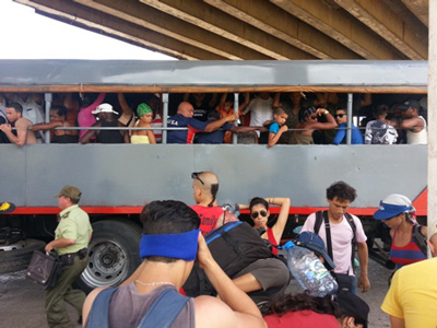
I set out with a dozen other people. There were three return visitors and nine newcomers, counting myself amongst the latter. We caught a “camion,” or transport truck, on the highway to Pinar del Rio near the 100th Street Bridge in Havana. We disembarked at Santa Cruz, took another bus to Fierro and then a dump truck to Sabanilla. The goal was to get to Sagua, a town in the heart of the Sierra del Rosario that serves as a sort of base camp for getting up “The Pan.”
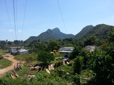
We got close to Sagua via lumber truck and then had to walk when the road turned bad. When we reached the campground of Mil Cumbres some friendly folks lent us a pot to cook spaghetti. Of course we had to bring all of our own food.
When the campground is not hosting foreign tourists it is open to Cubans, but being tourist high season we had no such luck. We bedded down for the night besides a stream a mile or so back from the official campsite.
After passing the first night wishing we had brought more blankets we set off for Sagua where we cooked lunch, again relying on the kindness of locals to lend us their porch and a pot to cook in.
That is where I learned that we would be getting river water for the rest of our trip as Sagua had no piped water due to some defect in the towns plumbing. Bring iodine tablets or bleach.
From Sagua the hike to the base of The Pan is about 8km. Along the way we passed a few farmers returning from their fields who told us about Rastafarians who used to visit The Pan to look for hallucinogenic mushrooms and smoke marijuana until the police chased them away.
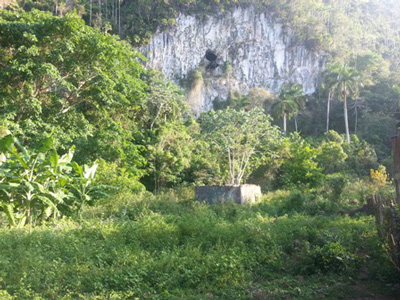
We also passed numerous entrances to caves which are visited periodically by ecotour groups and members of the Cuban Speleological Society.
At the base of the The Pan we found the last vestiges of human settlement before starting our ascent. A few people had built their houses out of the left overs of an old joint Soviet/Cuban military outpost.
While the rest of the group walked to a nearby stream to look for water I lazily talked to a woman from San Cristobal who has lived at the base of the Pan for the last few years. She and her husband raise pigs.
She told me they decided to settle in this area because the pigs can feed themselves in the forest. The drawback is that their livestock is often stolen. Also, the creole pigs they raise are not worth as much money as other breeds.
We talked about all of this over a bowl of stewed jutia meat, a varmint that can be kept for a pet or hunted for food, depending if it is the species that lives in trees or rummages on the forest floor.
I asked her if she had ever climbed The Pan. She has not.
We set out late, and by the time we were halfway up it was already dark. The path steep, mostly undeveloped and requires scrambling at times, even though no actual climbing equipment is required.
When we arrived at the top I was delighted to find the remains of an old military radar post. It was then I realized that this climb wasn´t even possible until the end of the Cold War as the whole area must have been closed off as a military zone.
Hulking shadows of rusting military hardware were cast by a full moon. As the wind was picking up we put up our tents in a brick building that must have once hosted Cuban and Soviet military personnel, now home to graffiti of present day visitors and remains of camp fires.
Morning´s daylight was filtered through a windy blanket of mist until the moisture was lifted by the suns heat.
The uninterrupted view was exactly as if flying in from Miami: the Gulf of Mexico on the left, the Sierra de Rosario on the right.
Click on the thumbnails below to view all the photos in this gallery. On your PC or laptop, you can use the directional arrows on the keyboard to move within the gallery. On cell phones use the keys on the screen.
The UN Security Council has given the go-ahead to a multinational armed mission for Haiti…
Jodie Newell from the United States took our photo of the day: "Lake Sabrina", in…
In Cuba, the official discourse of intolerance is directly intertwined with the dehumanization of those…
In order to improve navigation and features, Havana Times uses cookies.