Cuba Has 3 Days to Prepare for Hurricane Matthew

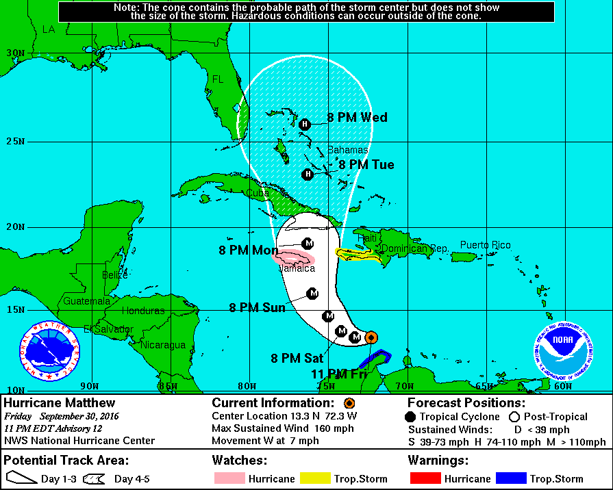
HAVANA TIMES — Hurricane Matthew became a monster storm on Friday and now has maximum sustained winds of 150 mph. Cuba’s civil defense network sprang into action today as they are not taking the threat lightly.
At 11 p.m. Cuba time (EDT), the Saffir-Simpson category four storm (the maximum is five) was moving west-southwest at 7 mph and was located around 450 miles southeast of Kingston, Jamaica.
The Cuban Weather Service (Insmet) expects Matthew to continue on its current course, slowing down its movement before tilting its path to the west and west-northwest on Saturday night. The intensity of the storm is expected to fluctuate, says Insmet.
“Taking into account the intensification and possible path of Matthew, a Hurricane Watch Phase was established for the provinces of Camaguey to Guantanamo as of 5:00 p.m. on Friday,” informed the Cuba’s National Civil Defense.
Thus far, the Civil Defense authorities are advising the population to keep up on the information available and to comply with the respective plans to reduce disasters.
Hurricanes are doubly dangerous in Cuba because of the poor state of a large percentage of the housing as well as a lack of materials such as plywood to board up for protection. Many Santiago de Cuba residents are still recovering from Hurricane Sandy in 2012.
According to the National Hurricane Center in Miami, Hurricane-force winds now extend outward up to 45 miles (75 km) from the center and tropical-storm-force winds extend outward up to 205 miles (335 km).
Rainfall totals of 10 to 15 inches with isolated maximum amounts of 25 inches are expected across Jamaica and southern and southwestern Haiti. So far the Center has not predicted the rainfall probabilities for Cuba.
Havana Times will bring a new report on Hurricane Matthew by noon on Saturday.


My houses in Niquero – Granma were built to stand up to very strong winds but a lot of houses in Granma could be damaged. I expect the Marea resort will close.