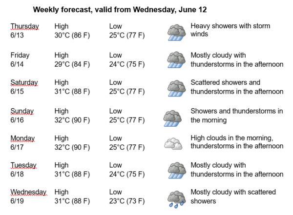
Havana Weather for June 13-19
Rains in Western Cuba …
By Adrian Fuentes
HAVANA TIMES – Conditions of instability remain over the northwest Caribbean Sea and the Gulf of Mexico, causing rainfall over Havana. These conditions are related to a trough in the mid and upper levels located in the southeast Gulf of Mexico, combined with a surface low-pressure center that generates a humid flow from the south over western Cuba.
In the coming days, clouds will predominate in the western half of the country, with showers, rain, and thunderstorms in the capital. Winds will mainly be from the southeast to east with speeds between 15 and 30 kilometers per hour. Relative humidity will range from 70% to 95%. High temperatures will range between 29 and 32ºC (84 and 90 F) and the Lows between 23 and 25ºC (73 and 77 F). The sea surface temperature will be 28ºC (82 F).
A low-pressure area is located over the northwest of the Florida peninsula. Although it is generating areas of thunderstorms, they remain disorganized in an environment where upper-level winds are not favorable for its development. The probability of tropical cyclone formation is low in the next 12 to 24 hours.
In the rest of the Atlantic Ocean, the Caribbean Sea, and the Gulf of Mexico, no tropical cyclonic development is expected in the next 12 to 24 hours.
How will the clogged drains of Havana cope with such volumes of water? The infrastructure of the “Capital for all Cubans”, is in a grim state of disrepair following sixty five years of neglect.. Much of the garbage will float !