Cuba/Irma: Warning from Guantanamo to Matanzas

By Circles Robinson
HAVANA TIMES – As Hurricane Irma churns west, currently near the north coastline of the Dominican Republic, preparations have stepped up in Cuba on alert from Guantanamo to Matanzas. Conditions could begin to deteriorate in the far eastern part of the island starting late tonight.
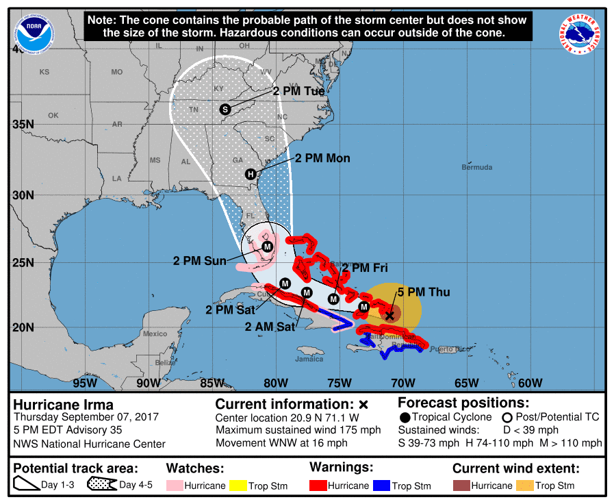
The current projection cone shows the eye of the storm going virtually parallel to the eastern and central northern Cuban coastline on Friday and Saturday before veering north towards Florida and where it may touch land several times on the eastern side of the peninsula.
At this time a landing somewhere in Central Cuba is still a possibility and the Civil Defense authorities have stepped up preparations.
While Havana is not mentioned in the current reports, the threat of a sea surge and coastal flooding is a latent possibility, as occurred in 2005 with hurricane Wilma, even though the center of that storm was much farther north.
Below is the bulletin put out by the National Hurricane Center with key information on the hurricane and the warnings in effect. It includes a discussion on possible developments in the coming hours and days.

Hurricane Irma Advisory
National Hurricane Center Miami FL
11:00 AM EDT Thu Sept. 7, 2017
...Extremely dangerous hurricane Irma is heading for the Turks and
Caicos islands…
…Hurricane and storm surge watch are now in effect for portions of
South Florida and the Florida keys…
Summary of 1100 am ast…1500 utc…information
———————————————–
LOCATION…20.4N 69.7W
ABOUT 75 MI…125 KM ENE OF PUERTO PLATA DOMINICAN REPUBLIC
ABOUT 120 MI…190 KM SE OF GRAND TURK ISLAND
MAXIMUM SUSTAINED WINDS…175 MPH…280 KM/H
PRESENT MOVEMENT…WNW OR 290 DEGREES AT 16 MPH…26 KM/H
MINIMUM CENTRAL PRESSURE…921 MB…27.20 INCHES
SUMMARY OF WATCHES AND WARNINGS IN EFFECT:
A Storm Surge Watch is in effect for…
* Jupiter Inlet southward around the Florida peninsula to Bonita
Beach
* Florida Keys
A Hurricane Warning is in effect for…
* Dominican Republic from Cabo Engano to the northern border with
Haiti
* Haiti from the northern border with the Dominican Republic to Le
Mole St. Nicholas
* Southeastern Bahamas and the Turks and Caicos Islands
* Central Bahamas
* Northwestern Bahamas
A Hurricane Watch is in effect for…
* Jupiter Inlet southward around the Florida peninsula to Bonita
Beach
* Florida Keys
* Lake Okeechobee
* Florida Bay
* Cuba from Matanzas province eastward to Guantanamo province
A Tropical Storm Warning is in effect for…
* Dominican Republic from south of Cabo Engano westward to the
southern border with Haiti
* Haiti from south of Le Mole St. Nicholas to Port-Au-Prince
* Cuba provinces of Guantanamo, Holguin, Las Tunas, Camaguey, Ciego
de Avila, Sancti Spiritus and Villa Clara.
A Storm Surge Watch means there is a possibility of life-
threatening inundation, from rising water moving inland from the
coastline, in the indicated locations during the next 48 hours.
For a depiction of areas at risk, please see the National Weather
Service Storm Surge Watch/Warning Graphic, available at
hurricanes.gov.
A Hurricane Warning means that hurricane conditions are expected
somewhere within the warning area. Preparations to protect life and
property should be rushed to completion.
A Hurricane Watch means that hurricane conditions are possible
within the watch area. A watch is typically issued 48 hours
before the anticipated first occurrence of tropical-storm-force
winds, conditions that make outside preparations difficult or
dangerous.
A Tropical Storm Warning means that tropical storm conditions are
expected somewhere within the warning area.
DISCUSSION AND 48-HOUR OUTLOOK
——————————
At 1100 AM AST (1500 UTC), the distinct eye of Hurricane Irma was
located near latitude 20.4 North, longitude 69.7 West. Irma is
moving toward the west-northwest near 16 mph (26 km/h), and this
general motion is expected to continue with some decrease in forward
speed for the next couple of days. On the forecast track, the eye
of Irma should continue to move just north of the coast of
Hispaniola today, be near the Turks and Caicos and southeastern
Bahamas by this evening, and then be near the central Bahamas by
Friday.
Maximum sustained winds are near 175 mph (280 km/h) with higher
gusts. Irma is a category 5 hurricane on the Saffir-Simpson
Hurricane Wind Scale. Some fluctuations in intensity are likely
during the next day or two, but Irma is forecast to remain a
powerful category 4 or 5 hurricane during the next couple of
days.
Hurricane-force winds extend outward up to 60 miles (95 km) from the
center and tropical-storm-force winds extend outward up to 185 miles
(295 km).
The minimum central pressure reported by an Air Force plane was 921
mb (27.20 inches).
HAZARDS AFFECTING LAND
———————-
STORM SURGE: The combination of a dangerous storm surge and the
tide will cause normally dry areas near the coast to be flooded by
rising waters moving inland from the shoreline. The water is
expected to reach the following HEIGHTS ABOVE GROUND if the peak
surge occurs at the time of high tide…
The combination of a life-threatening storm surge and large breaking
waves will raise water levels ABOVE NORMAL TIDE LEVELS by the
following amounts within the hurricane warning area near and to the
north of the center of Irma. Near the coast, the surge will be
accompanied by large and destructive waves.
Turks and Caicos Islands…15 to 20 ft
Southeastern and central Bahamas…15 to 20 ft
Northwestern Bahamas…5 to 10 ft
Northern coast of the Dominican Republic…3 to 5 ft
Northern coast of Haiti and the Gulf of Gonave…1 to 3 ft
Northern coast of Cuba in the warning area…5 to 10 ft
Water levels around Puerto Rico should subside today.
WIND: Hurricane conditions are expected to begin within the
hurricane warning area in the Dominican Republic and Haiti today.
Hurricane conditions are expected to begin in the southeastern
Bahamas and the Turks and Caicos Islands later today with tropical
storm conditions expected within the next several hours. These
conditions will spread into the central Bahamas by tonight or early
Friday.
Hurricane and tropical storm conditions are possible within the
watch area in Cuba by Friday. Tropical storm conditions are
expected to begin within the warning area in Cuba tonight.
Hurricane conditions are expected in the northwestern Bahamas Friday
night and Saturday.
RAINFALL: Irma is expected to produce the following rain
accumulations through Saturday evening:
Northeast Puerto Rico and the British and U.S. Virgin Islands…
additional 2 to 4 inches, isolated 6 inches
Much of the Bahamas and Turks and Caicos…8 to 12 inches, isolated
20 inches
Andros Island and Bimini, Bahamas…12 to 16 inches, isolated 25
inches
Northern Dominican Republic and northern Haiti…4 to 10 inches,
isolated 15 inches
Southern Dominican Republic and southern Haiti…2 to 5 inches
Eastern and central Cuba…4 to 10 inches, isolated 15 inches
Southeast Florida and the upper Florida Keys…8 to 12 inches,
isolated 20 inches
Lower Florida Keys…2 to 5 inches
In all areas this rainfall may cause life-threatening flash floods
and mudslides.
SURF: Swells generated by Irma are affecting the northern Leeward
Islands, Puerto Rico, the Virgin Islands, the southeastern Bahamas,
the Turks and Caicos Islands, the northern coast of the Dominican
Republic, and should start affecting portions of the southeast
coast of the United States later today and tonight. These swells
are likely to cause life-threatening surf and rip current
conditions.


and to you in Havana, Eden!
There’s never an upside to these storms, but at least for Cuba is appears it might not be a total direct hit this time.
All the best to everyone.
I recommend that if any family member has a bank account, transfer money from your account directly to theirs. Reason? Western Union fees are 8% for transfers of $150 – $1,000 and 7% for $1,000 – $40,000. Canadian banks for example charge a flat fee of $35 for transfers into Cuban bank accounts equating to 3.5% on $1,000 or 0.35% on $10,000. Western Union is expensive!
Your house Bcoesa 300% must be close to the church and that tiny trova in Baracoa. I wish safety for all the people there and elsewhere.
I hope that my family can find a safe place where to be and that none of them dye.I hope i don’t loose my house, two blocks away from the ocean in Baracoa, Guantanamo. If anyone wishes to help their family in Cuba financially i recommend Western Union. I used their services yesterday and it was easy and fast, today in the morning my mom had received the money transfer. i hope my friends can find shelter in safer places than their homes.
A natural phenomenon, Irma will have affected millions, irrespective of politics, race or religion. Lives, homes, infrastructure and environment all suffer. All of us should have concern for those who are affected. Politicians can warn and endeavour to mitigate, but in reality are powerless to prevent. Their role is to try to aid those affected after Irma passes.
Stay safe Cuba amigos