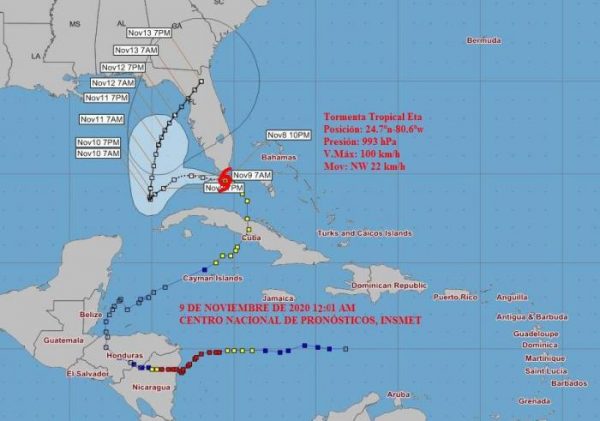
Eta Moves in the Gulf, North of Western Cuba

HAVANA TIMES – Cuban authorities are currently verifying the damage caused by Eta in the center of the country. Meanwhile, the storm is moving in the Gulf of Mexico. It’s still too close to the north coast of western Cuba to trust. Therefore, precautionary measures are maintained in Havana and Pinar del Río where there may be coastal flooding.
Eta is expected to turn north on Tuesday, heading for the east coast of Florida.
Next, we publish the latest notice from the Cuba Forecast Center (Insmet).
TROPICAL STROM ETA
Insmet Forecast Center, November 9, 9:00 a.m.
… Eta moves over the southeast of the Gulf of Mexico …
During the early morning, Tropical Storm Eta has had little change in organization and intensity. It maintains maximum sustained winds of 60 mph (100 kp/h) with higher gusts, with a central pressure of 992 millibars.
At nine in the morning its center was estimated at 25.0 degrees North latitude and 83.2 degrees West longitude. That placed it at 220 kilometers northwest of Havana and about 235 kilometers north of Bahia Honda, Artemisa.
Eta is now moving towards the west, at a rate of 12 mph (20 kp/h). In the coming hours it will incline its trajectory to the west-southwest. Therefore, it will continue its movement over the southeast of the Gulf of Mexico. During this displacement, it can gradually gain in organization and intensity, with the possibility of turning into a hurricane on Tuesday.
The areas of showers and rains associated with the wide circulation of Eta, have persisted over the western half of Cuba. Likewise, to the east of the island. The rain bands, with some thunderstorms, will continue to influence the west and center, as well as the southeast, where they can still become strong and locally intense rains mainly from late morning.
Flood danger remains in low lying areas
Given the abundant rainfall received in the last 48 hours, with the saturation of soils, floods may occur in low lying areas with poor drainage.
Winds on the northwestern coast, with speeds between 25 and 40 km/h and higher gusts are forecast for the afternoon. These winds may be somewhat stronger at night in areas of the north coast of the province of Pinar del Rio.
From the morning on, the sea swells will decrease on the north coast, but remain in the afternoon in the extreme west.


