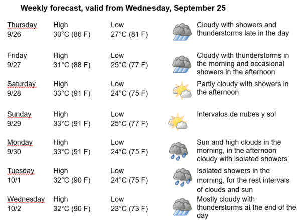
Havana Weather for Sept. 26 to Oct. 2

…Rain and Winds in Havana After the Passage of Helene…
By Adrian Fuentes
HAVANA TIMES – Hurricane Helene is currently in the Gulf of Mexico, moving north at a speed of 19 km/h (12 mph), with a current intensity of 140 km/h (85 mph), classifying it as a category one hurricane on the Saffir-Simpson scale, which has a maximum of five. However, it is forecasted that its intensity will increase to more than 210 km/h (125 mph), making it a category four hurricane on the Saffir-Simpson scale when it makes landfall in northwest Florida on Thursday afternoon/evening.
Over the next few days, rain will continue in the capital, which could become heavy and intense in some areas, potentially persisting until the weekend. In areas with showers and thunderstorms, there may be an increase in wind strength and wave height, even in zones far from the center of circulation of this hurricane. Winds will primarily be from the southeast, with speeds between 15 and 30 kilometers per hour, with stronger gusts. Relative humidity will range from 50% to 80%. Highs will range between 30 and 33ºC (86 and 91 F) and lows between 23 and 27ºC (73 and 81 F). The surface temperature of the sea will be 30ºC (86 F).
At 5 p.m. Cuba time (4 CDT), Helene was located in the Gulf of Mexico, approximately 735 kilometers southwest of Tampa, Florida. The storm was moving north at a speed of 19 km/h and showed signs of intensification. It is expected to continue on its path reaching the northwest coast of Florida on Thursday afternoon/evening. Forecast models indicate that as it approaches land, Helene could strengthen in organization and intensity to become a category four hurricane. This trajectory could cause significant impacts on the coast, as well as indirect effects in Havana, such as increased waves and potential rain.


