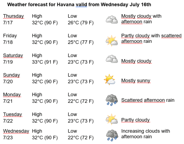
Havana Weather for July 17 to 23

Rain in Western Cuba…
By Adrian Fuentes
HAVANA TIMES – The subtropical high-pressure systems continue to influence Cuba, generating weak and variable winds across much of the country, including the capital. Meanwhile, a low-pressure area is located over the northeastern Gulf of Mexico and the northwestern Florida peninsula. This system is associated with disorganized areas of cloudiness, rain, and thunderstorms, mainly concentrated east of its center. It is well-defined in the lower and middle levels of the atmosphere but displaced southward at higher altitudes, which has increased the relative humidity in those layers from the eastern Gulf of Mexico to Cuba, encouraging abundant cloud cover over Havana.
Today, the low-pressure area will move westward, maintaining unstable conditions in the region that will bring showers, rain, and thunderstorms starting in the morning in the Cuban capital. This rain will combine with the typical afternoon instability of the season. Rainfall will be widespread, especially in inland and southern areas. For now, the system has a low probability of developing into a tropical cyclone in the coming hours.
In the coming days, it will remain cloudy in Havana, with isolated showers and rain in inland areas during the morning, which will shift toward the northern coast in the afternoon. Winds will be mainly from the east to northeast, with speeds between 15 and 30 kilometers per hour. Relative humidity will range from a minimum of 65% to a maximum of 90%. High temperatures will range from 32 to 33ºC (90 to 91°F) and lows from 22 to 26ºC (72 to 79°F). Sea surface temperatures will be 29ºC (84°F).
In the Atlantic Ocean, Caribbean Sea, and Gulf of Mexico, no tropical cyclone development is expected in the next 12 to 24 hours.