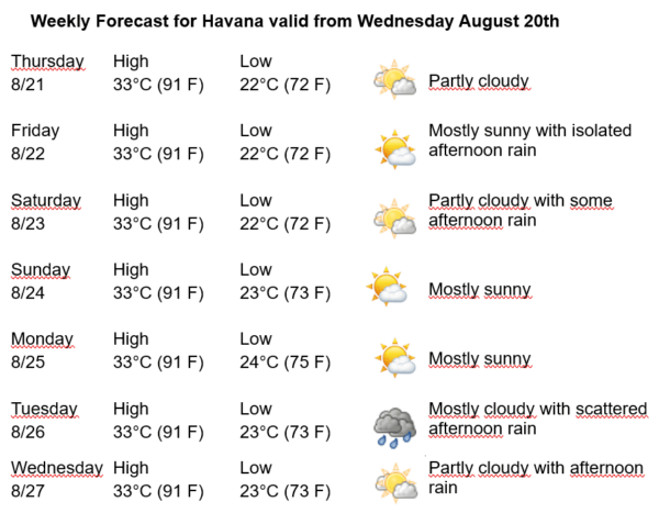
Havana Weather for August 21 to 27

Isolated showers in the interior and along the north coast…
HAVANA TIMES – The Forecast Center of the Cuban Institute of Meteorology is issuing Tropical Cyclone Advisories on Hurricane Erin, which remains a Category 2 hurricane on the Saffir-Simpson scale, with a maximum of five. At 2 p.m., it was located at 30.6 degrees North latitude and 73.6 degrees West longitude, a position that places it about 855 kilometers west of Bermuda and about 540 kilometers south-southeast of Cape Hatteras, North Carolina. This hurricane is moving northward at a translational speed of 20 kilometers per hour. Maximum sustained winds reach 175 kilometers per hour (109 mph) with a minimum central pressure of 943 millibars.
Over Cuba and the adjacent seas, the broad outer circulation of Erin at the surface is exerting a weak influence. It is expected that a moist flow will continue to be present up to mid-levels due to the outer circulation of this system, which, combined with afternoon instability and favorable local factors, will cause cloudiness in Havana in the afternoon, with isolated rainfall occurring.
In the coming days, the capital will dawn with little cloud cover. In the afternoon it will become cloudy inland and along the north coast, with some showers, rain, and thunderstorms. Winds will be mainly from the northeast, with speeds between 10 and 25 kilometers per hour. Relative humidity will be 60% to 90%. Highs will be around 33ºC (91 F) and lows between 22 and 24ºC (72 and 75 F). The sea surface temperature will be 30ºC (86 F).
In the rest of the Atlantic Ocean, Caribbean Sea, and Gulf of Mexico, no tropical cyclone development is expected in the next 12 to 24 hours.