Hurricane Irene Tipping Away from Cuba
by Circles Robinson

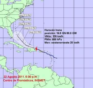
HAVANA TIMES, August 22 — Hurricane Irene has inclined its course near the north coast of Hispaniola Island (Dominican Republic and Haiti) and the threat of a direct hit to eastern Cuba is now considerably less than earlier projections.
The storm with maximum sustained 80 mph winds (130 kph) could intensify in the coming 24-48 hours notes the Cuban Weather Service (INSMET). The central pressure was pegged at 988 millibars.
In passing over Puerto Rico, the storm felled trees and caused flooding but no injuries have been thus far reported.
A hurricane warning is in effect for the entire north coast of the DR and a tropical storm warning for all of Haiti. While the center of the storm may not strike land in those countries heavy rains are of concern to local authorities.
INSMET maintains a strict vigilance of the evolution of Irene as dangerous heavy seas will continue on the north coast of Cuba’s easternmost province, Guantanamo, increasing by Tuesday morning. Heavy rains could also fall in mountainous areas of Cuba’s northeast coast on Tuesday night and Wednesday morning, said the weather service.
INSMET notes that winds of 15 to 25 mph will begin to be felt on the north coast of eastern Cuba by Tuesday night.
Meanwhile, the Central Bahamas including the Turk and Caicos Islands are facing a direct threat in the coming two days.
The National Weather Service in Miami is predicting Irene will become a major hurricane with winds of 110 mph by Thursday when it takes aim on the US southeast Atlantic coast and a possible landing in South or North Carolina.


