Summary of 2020 Hurricane Season
By Yanet Díaz
HAVANA TIMES – The recent 2020 hurricane season that has just come to an end, was particularly active. A total of 30 tropical cyclones formed, which was a historic record. The previous high was 28 cyclones, in 2005.
If we compare this with the average hurricane season, we can see a lot more activity this season, as normally only 12 cyclones form in the Atlantic per year, meaning that 2020 was well above this number (see the table).

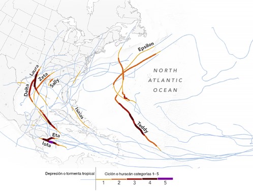
Out of these 30 tropical storms, only two of them reached Cuban soil: Laura and Eta, which arrived under the tropical storm intensity (between 63 and 118 km/h) and swept through Pinar del Rio and Sancti Spiritus, respectively.
This 2020 season was the second time that the Greek alphabet had to be used to name hurricanes because the names proposed for this season were all used up. This has only happened once before, in 2005.
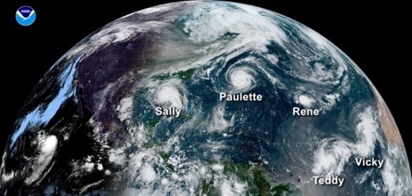
Another highlight of the 2020 season was the coexistence of 5 tropical cyclones in the Atlantic at the same time: Sally, Paulette, Rene, Teddy and Vicky. This happened on September 14th and is the second time that something like this has happened in the Atlantic, at least as far as records go. In the following diagram, you can see where these five tropical cyclones were located.

November was surprisingly active
Another noteworthy feature of the 2020 hurricane season is that it was the first time in history that two high-intensity hurricanes were recorded in the month of November (Eta and Iota), which is quite unusual as only one high-intensity hurricane is expected to form every eight years. These two hurricanes hit Central America pretty hard, touching Nicaraguan soil twice in the same place and very soon one after the other, which is unprecedented in this region.
Hurricane Iota was the only one that reached category 5 in this period of the season (November 13th-18th), as more intense hurricanes normally form in September. As a result, we can see that activity was quite extreme and unusual in November.
That said, what were the factors that led to this increased activity? Sea surface temperature is one of the main factors, which has been a lot warmer than normal in the Atlantic ever since early spring. Another important factor was the development of La Nina (El Nino’s cold counterpart), with weaker trade winds from the Atlantic and Caribbean, which prevented colder deep water from moving to the surface, allowing warm pools to form that favor cyclogenesis and hurricanes gaining greater intensity much faster.
The following diagram shows all of the journeys hurricanes took this season. You can see that only two tropical storms passed through Cuba, Laura in the west and Eta in the country’s central region.

References:
National Hurricane Center Monthly Atlantic Tropical Weather Summary.
Yale Climate Connections A look back at the horrific 2020 Atlantic hurricane season.
NOAA Record-breaking Atlantic hurricane season draws to an end.
NASA Earth Observatory: A destructive abundance


