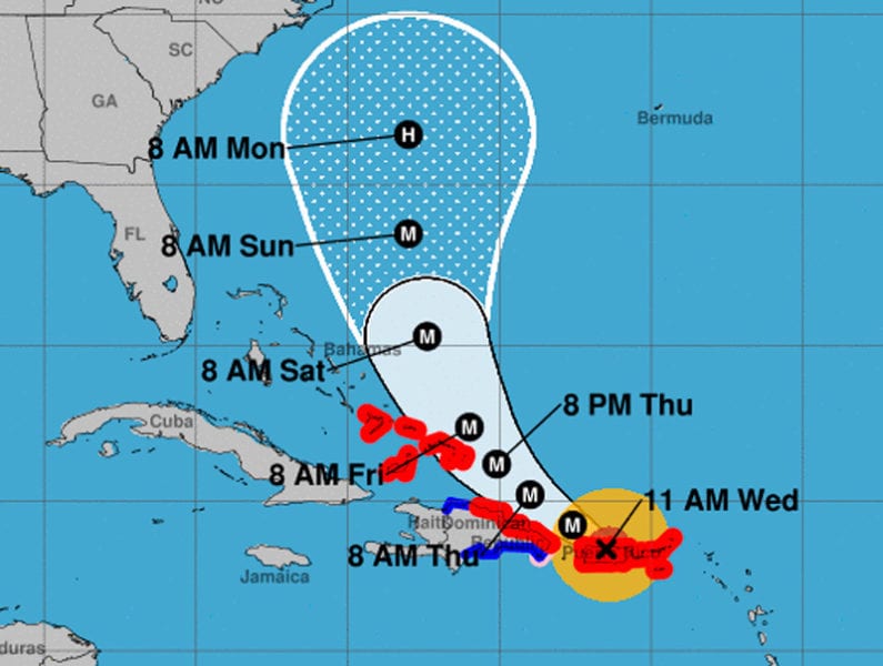
Cuba Prepares for Hurricane Maria

By Circles Robinson
HAVANA TIMES – While most of Cuba is still involved in the long recovery work after Hurricane Irma, now a new phenomenon, Maria, threatens to cause flooding and damages on the northeastern coast of the island.
Last night the Cuban Civil Defense issued an early hurricane alert for the provinces of Holguin and Guantanamo, where, although far from the center of Maria, there may be heavy rains, high winds and coastal flooding.
Today, Maria is pounding Puerto Rico with winds of 250 kilometers per hour with torrential rains, after leaving a trail of death and destruction in Dominica and other islands of the Caribbean east.
It is predicted that Maria’s course after crossing the whole island of Puerto Rico, passing over or very near the capital San Juan, will be bordering the north coast of the Dominican Republic, and from there turn more to the north.
The following is the warning from Cuba’s Civil Defense authorities.
Cuba’s Civil Defense issues early alert for Hurricane Maria
Because of the course the hurricane is predicted to take, strong gusts of winds will be felt in the far eastern provinces of our country on the north-eastern coast as of Thursday Sept. 21st.
According to the Cuban Meteorology Institute’s reports, dangerous Hurricane Maria reached category 5 on the Saffir-Simpson scale and is heading towards the west/north-west.
Because of the course of the hurricane, strong gusts of winds will be felt in the far eastern provinces of our country on the north-eastern coast as of Thursday. On Friday the 22nd, tides will get higher with waves between 3.0-3.5 meters blowing from the northeast. Strong sea surges are expected on the northern coast along the section that stretches from Moa to Punta de Maisi, causing moderate coastal flooding in low-lying areas on this coast, mainly in Baracoa city.
A lot of rain, linked to just how close Maria is, might hit the eastern region, because of the influence of some of the hurricane’s external rings, causing heavy rains in some localities, mainly in mountainous areas as of Thursday Sept. 21st at night.
State authorities and organizations, businesses and social institutions in the provinces of Guantanamo and Holguin should keep themselves informed of the Meteorology Institute’s reports about how this hurricane develops, especially because of the influence of sea surges.
Work related to unblocking and clearing rubble, cleaning and hygiene in coastal areas on the northern coast of these provinces should continue as well as remaining alert about possible flooding due to heavy rains, especially in mountainous areas and runoff, as well as the effect strong gusts of wind might have.
It’s important to increase awareness among the population about norms of conduct, protective measures and actions that they must comply with, indicated in family guides and in disaster reduction plans, via state-owned mass media and alternative platforms that are directly linked to high-risk communities.
National Civil Defense along with the National Forecast Center, which belongs to the Meteorology Institute (Insmet), are constantly updating their reports and watching to see how this hurricane develops.


They will clean up until dead tired, then — have some rum and fruit-juices — some will go to bed, others will dance and go to bed — not-alone.
I wonder, since the USA has turned its back to Puerto Rico — if PR could join Cuba? Hey why not? Trump no like no brown people . . . no colored ones — and all that.
how wil it be on sept 26