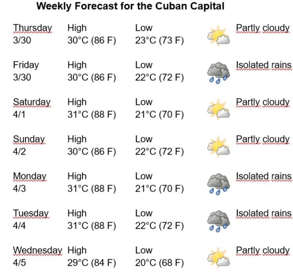
Havana Weather for March 30 to April 5

Warm and isolated rains in western Cuba…
By Adrian Fuentes
HAVANA TIMES – A cold front extends from the center of the Florida peninsula to the west and then south to the coast of Mexico, with scattered moderate convection with strong winds to the north of the front which decrease their intensity in the southern part of the front. There is no significant deep convection occurring over the Caribbean today.
The cold front will weaken as it moves toward the south of Florida, dissipating over the southeastern tip of the Gulf late Thursday afternoon. Moderate northeasterly to easterly winds will gradually decrease by tonight, while the influence of high pressure over the southeastern United States will increase later in the week. A regime of strong trade winds will be imposed over the central Caribbean, which will weaken slightly by the beginning of the week.
A ridge to the north of the Caribbean is combined with a low-pressure center over northern South America, imposing a generally moderate trade wind regime from NE to E over the central and southern Caribbean, with speeds between 10 and 25 km/ h. The relative humidity will be between 70% and 85%. The high temperatures will be between 29 and 31ºC (84 and 88 F) and the lows between 20 and 23ºC (68 and 73 F). The sea surface temperature will be 26ºC (79 F).


