Havana Weather for November 5-11
Expect a rainy week in Havana
By Yanet Díaz
HAVANA TIMES – There are still bands of clouds associated with the stationary cold front over eastern Cuba, producing numerous intermittent showers in the capital. The rains will continue due to the presence of this dissipating front. Likewise, abundant humidity in the lower and middle levels of the atmosphere, which stimulates cloud formation and rain.
One aspect to highlight is the strong winds that will take place during these days, due to the northeast flow from the passage of the cold front. These winds may reach gusts of up to 50 km/h, causing sea surges and possibly some coastal flooding on the Havana coastline.
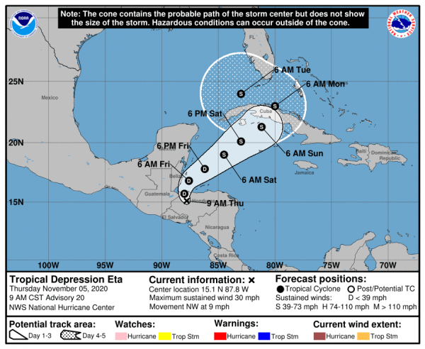
Tropical depression Eta
On the other hand, the now tropical depression Eta could pose a threat to Cuban territory; Although it is now still east of Tegucigalpa, Honduras, it is moving west at an approximate speed of 13 km/h, so if it continues with this trajectory it could be crossing the island beginning this Saturday in the evening hours.
Eta has a minimum central pressure of 1006 hectoPascals, and maximum sustained winds of 50 km/h with higher gusts. However, once it returns to the Caribbean Sea it is possible that it will intensify again as a tropical storm (see track cone of the National Hurricane Center).

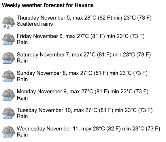
Therefore, for this 7-day period, bad weather is forecast to continue in the Cuban capital, with intermittent showers and rains that will become locally intense. Humidity will remain very high at 90-95%. There will be a slight drop in temperatures, with highs between 27 and 28° C (81 and 82 F) and lows around 23° C (73 F). The sea surface temperature will remain warm at 30° C (86 F).
In the North Atlantic, the Gulf of Mexico and the Caribbean Sea, no new formation of another tropical cyclone is expected in the next 5 days.


Sorry to see that CUBA is once again going to be hit with a seasonal hurricane. And no real Emergency Management shelter or supplies for it’s people!