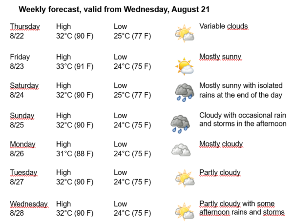
Havana Weather for August 22-28

Hot and isolated rains in the Capital…
By Adrian Fuentes
HAVANA TIMES – Cuba remains on the periphery of the North Atlantic Subtropical Anticyclone, which continues to impose light surface winds, which in the afternoon towards the northern coastal areas will have a northeast to east component. Meanwhile, in the upper troposphere, an upper-level low persists in the southeast of the Gulf of Mexico, while a tropical wave is located in the northwest of the Caribbean Sea. Despite the presence of these systems near the national territory, the low moisture content in the lower layers of the atmosphere will somewhat limit precipitation. Therefore, isolated showers are expected in Havana in the coming days.
Under these conditions, we will have little cloudiness at dawn in most of the capital. By late morning, it will be partly cloudy, with increased cloudiness in the afternoon in the interior and southern areas, bringing some showers, rain, and thunderstorms. Winds will be mainly from the east to northeast, with speeds between 15 and 30 kilometers per hour. Relative humidity will range from 40% to 60%. High temperatures will be between 31 and 33ºC (88 and 91 F), and the lows at 24 and 25ºC (75 and 77 F). The sea surface temperature will be 30ºC (86 F).
No tropical cyclone development is expected in the Atlantic Ocean, Caribbean Sea, or Gulf of Mexico within the next 12 to 24 hours.