Havana Weather for October 10-16

Swells and coastal flooding in the west…
By Adrian Fuentes
HAVANA TIMES – While Hurricane Milton is strongly affecting Florida, strong swells will continue on the northwestern coast of Cuba, with moderate coastal flooding, which will begin to decrease starting Thursday afternoon. There will be swells on the southern coast of the west, decreasing to waves, with coastal flooding that will gradually begin to subside from the morning.
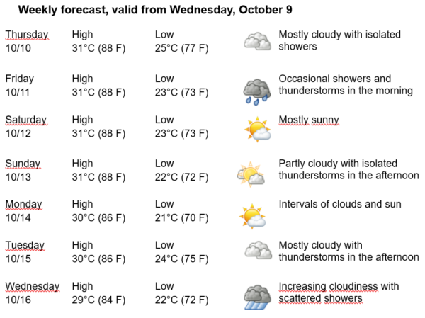
Under these conditions, the forecast for the coming days is for cloudy mornings with some showers, rain, and isolated thunderstorms in the capital. Winds will be from the southwest to west in the morning, shifting to the northwest in the afternoon at speeds between 15 and 30 kilometers per hour, with stronger gusts. Relative humidity will range between 80% and 100%. High temperatures will be between 29 and 31ºC (84 and 88 F), and the lows between 21 and 25ºC (70 and 77 F). The sea surface temperature will be 30ºC (86 F).
Note: In areas of showers and thunderstorms, wind strength and wave height can increase locally.
Hurricane Milton has continued moving northeast at a speed of 24 kilometers per hour (15 mph) and is very close to the western coast of Florida. In the afternoon, it has experienced fluctuations in intensity, though it remains a Category 3 hurricane on the Saffir-Simpson scale. As of 8 PM (ET), its maximum sustained winds are 195 kilometers per hour, with stronger gusts, and its minimum central pressure has risen to 954 millibars.
At 8 PM, its center was located at 27.2N degrees north latitude and 82.8W degrees west longitude, which places it about 30 kilometers southwest of Sarasota, on the Florida peninsula.
In the next 12 to 24 hours, this system is expected to continue moving northeast at a similar speed, to make landfall tonight just south of Tampa Bay. It should then shift east-northeast over central Florida and exit back into the sea on Thursday via the Atlantic coast.


