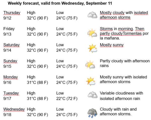
Havana Weather for September 12-18

…hot and some afternoon rain…
By Adrian Fuentes
HAVANA TIMES – Cuba remains under the weak influence of oceanic high pressures, a system that keeps its center mainly far away in the eastern Atlantic Ocean. On the other hand, a tropical wave will be moving today over the seas south of the national territory, which, combined with local factors and daytime heating, will stimulate some rain in areas along Havana’s northern coast.
Over the next few days, the mornings will begin partly cloudy in the capital. In the afternoon, it will become cloudy inland and in the northern coastal areas, with some showers, rain, and thunderstorms. Winds will mainly come from the northeast at speeds between 10 and 25 kilometers per hour. Relative humidity will range from a minimum of 60% to a maximum of 90%. High temperatures will be between 31 and 32ºC (88 and 90 F), and lows will range from 22 to 24ºC (72 and 75 F). The sea surface temperature will be 30ºC (86 F).
Monitoring continues for Hurricane Francine, which is located in the northwest of the Gulf of Mexico, approximately 375 kilometers southwest of New Orleans, Louisiana. This system has maximum sustained winds of 150 kilometers per hour, with stronger gusts, and its minimum central pressure has dropped to 976 hPa. It is moving northeast at 19 kilometers per hour. Today, Francine will increase its speed, making landfall somewhere in Louisiana.
To the east of the Lesser Antilles arc, over the central Atlantic, there is a low-pressure area associated with disorganized rain and thunderstorms. Environmental conditions are not favorable for it to develop into a tropical system over the next few days, as the system moves westward across the tropical Atlantic.
Another low-pressure area, embedded in the heart of a tropical wave, is located over the seas west-southwest of the Cape Verde Islands. This system has associated rain and thunderstorms, which have shown signs of organization in recent hours. Environmental conditions in this case appear favorable for it to develop into a tropical depression over the coming days.
No tropical cyclone development is expected in the rest of the Atlantic Ocean, the Caribbean Sea, or the Gulf of Mexico within the next 12 to 24 hours.


