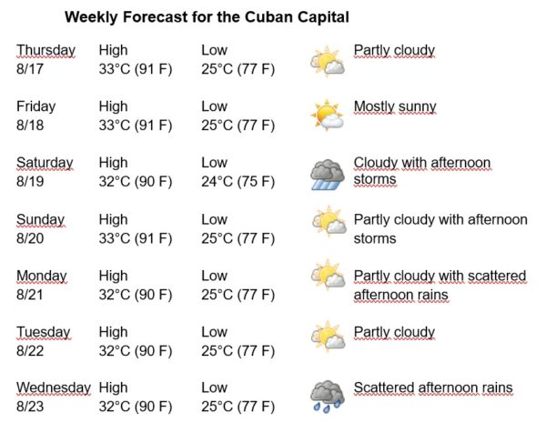
Havana Weather for August 17-23

Another hot week with scattered afternoon rains
By Adrian Fuentes
HAVANA TIMES – Cuba and adjacent seas are on the periphery of the influence of the North Atlantic Subtropical Anticyclone. In the low and middle levels of the atmosphere a trough is located over the west of the country, represented on the surface by a depression in the southeast of the Gulf of Mexico, very close to the national territory. The presence of these systems, together with high humidity in the upper atmosphere, is causing layered clouds over Havana, which will remain for the next few days.
The combination of local factors and daytime heating will be stimulating some rains in the Cuban capital, mostly in the afternoons. The winds will be mainly from the northeast, with speeds between 15 and 30 km/h. The relative humidity will range between 80% and 100%. The high temperatures will be 32 and 33ºC (90 and 91 F) and the lows 24 and 25ºC (75 and 77 F). The sea surface temperature will be 31ºC (88 F).
In the seas close to the coasts of Africa, a tropical wave moves which is associated with disorganized areas of clouds and storms. In the next few days this system could give rise to the formation of a low-pressure center when it moves over or close to the Cape Verde Islands.
Another area of clouds and electrical storms is in the central tropical Atlantic, associated with a trough. An area of low pressure should also form within this system in the coming days when it continues to move west across the central Atlantic.
In the rest of the area of the Atlantic Ocean, the Caribbean Sea and the Gulf of Mexico, tropical cyclone development is not expected in the next 12 to 24 hours.


