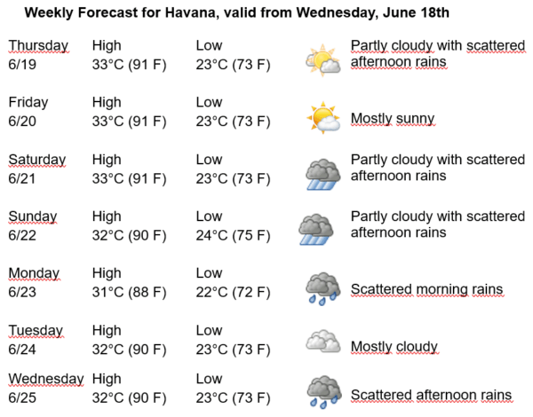
Havana Weather for June 19-25
Increase in afternoon rains…
By Adrian Fuentes
HAVANA TIMES – During the past twenty-four hours, an active tropical wave passed through the seas south of the western half of the Cuban archipelago. In addition, in the lower atmospheric layers, a moderately humid southeast to south flow continues to arrive in the country. This setup, combined with local-scale factors and afternoon instability, has led to the occurrence of some showers, rain, and thunderstorms in Havana.
At this hour, satellite images show mostly partly cloudy skies over much of the national territory. In the coming days, the persistent southeasterly flow from the surface up to about 3 kilometers high will continue to bring moderate levels of relative humidity, which, along with local convection, will favor the development of showers, rain, and thunderstorms in the capital.
Forecasts indicate that the mornings will begin with little cloudiness in the coming days. From late morning onward, it will become partly cloudy, with increasing cloud cover over inland and southern areas of Havana, where isolated showers, rain, and thunderstorms may occur.
Winds will be mainly from the east to northeast at speeds between 15 and 30 kilometers per hour (9 to 18 mph). Relative humidity will range from a minimum of 60% to a maximum of 100%. Highs will be between 31 and 33ºC (88 to 91ºF), and lows between 22 and 24ºC (72 to 75ºF). Sea surface temperatures will be 28ºC (82ºF).
In the Atlantic Ocean, Caribbean Sea, and Gulf of Mexico, no tropical cyclone development is expected in the next 12 to 24 hours.