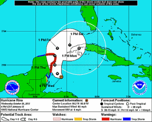
Rina Approaches Yucatan, Cuba Next?
By Circles Robinson

HAVANA TIMES, Oct. 26 — Hurricane Rina has weakened some in intensity but still packs 85 mph (140 kph) maximum sustained winds as it moves towards a possible landing on the Mexican Yucatan sometime Thursday.
While expected to weaken further after touching land, the path of Rina after Mexico could lead it towards Cuba or south Florida, possibly as a tropical storm.
Heavy rains are possible in western Cuba and the possibility of sea swells is being closely watched by Cuban authorities.
At 6:00 p.m. on Wednesday, the Cuba Weather Service (INSMET) located the center of Rina at 160 miles (265 kms.) southeast of Cozumel, Mexico. It was moving on a northwest track at 6 mph (9 kph).
INSMET forecasts that during the next 24 to 48 hours their will be little change in the intensity of the Category One hurricane and expects it to tilt its path to the north in preparation for a landing on the Yucatan peninsula on Thursday.
The next advisory from the Cuban weather experts will be forthcoming at 6:00 a.m. local time (EDT) on Thursday.


