Increased Land Controls Push Migrants to Use Water Routes
Most of the routes are more expensive and more dangerous, only serving to evade a few controls while traveling through Mexico to reach the United States.
HAVANA TIMES – Amid the increase in the massive flight of Nicaraguans who risk their lives to enter the United States irregularly, some have reported the use of waterways that “coyotes” offer them as new and safer itineraries. However, these routes are actually more dangerous because the instability of the boats they use expose them to accidents and, in addition, they are controlled by organized crime, which does not like migrants to use them.
Nevertheless, every time land controls increase, as is currently the case to stop the advance of Venezuelan migrants, these routes resurface as an option to evade them, even if they are more expensive and riskier.
“These routes are managed by organized crime to transfer drugs and contraband, so they do not want migrants to pass through there because they attract the attention of the authorities and the media. So, with the focus of attention on them, they deactivate those routes and stop using them. Also, the routes are not for mass use,” says Ruben Figueroa, of the Mesoamerican Migrant Movement and director of the Bridges of Hope Project, which searches for missing migrants.
The best known and most used water routes
According to information provided by people who know these routes, the following are the most well-known and most used water routes to evade immigration controls on Mexico’s southern border:
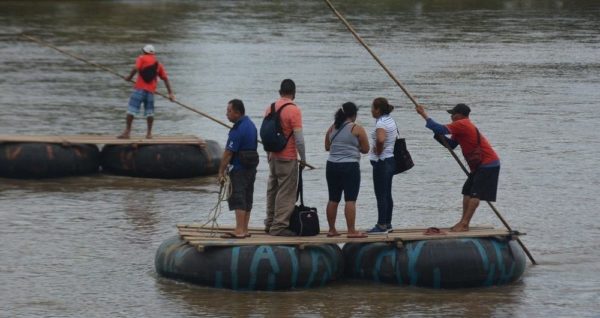
1. The Suchiate River. In Tecum Uman, Guatemala, migrants take rafts fitted with tires attached by boards. This is an option for crossing the border and entering Mexico. The journey is short, and it costs, on average, 5 dollars to cross. In summer many just walk across since the river isn’t even two meters deep. This route is mostly used by smugglers.
2. Between coastal areas of San Marcos and Retalhuleu in Guatemala and the State of Oaxaca, in Mexico.
3. In Mexico between Tapachula, Chiapas and Oaxaca.
4. Also in Mexico, the territory between Oaxaca and Colima.
5. On the northern border, between the coastal area of Rosarito and Ensenada in Baja California, Mexico, and the beaches of California in the United States. This is considered even more dangerous because of the strength and temperature of the waters.
Increased ground surveillance reactivates water routes
According to Figueroa, in 2015 water routes near Mexico’s southern border boomed after the Mexican government established the Southern Border Plan Program. This plan, to stem the flow of migrants to the United States, detained and repatriated migrants. However, soon the pressures of organized crime forced human traffickers to stop using them.
Between 2018 and 2019 their use was reactivated more strongly when land controls increased to try to stop the advance of caravans in which thousands of people advanced towards the northern border. Currently, the large number of Venezuelan migrants trying to cross the border into the US could be prompting some people to resume using these routes.
The northern border route gained strength in 2020 to evade the controls imposed by Title 42 when, with the excuse of slowing the advance of the covid-19 pandemic, the United States returned migrants who crossed its border, to Mexico. In 2021 this route caught the attention of the media when, on the coast of San Diego, California, waves crashed a boat loaded with migrants against the rocks. Three people died in the shipwreck.
They are more expensive and dangerous routes
According to users, these routes cost between 400 and 500 dollars and in the end only serve to evade some ground controls. Figueroa says that in the case of the routes used on the southern border they serve to evade about ten immigration checkpoints located between Tapachula and Oaxaca.
In addition to being expensive, they are also more dangerous because of the type of boats they use. In addition, the trip takes hours, in many cases more than it should because the boats are “town surfing”. That is, looking for fuel in the coastal towns or simply extending the trip to justify the charge.
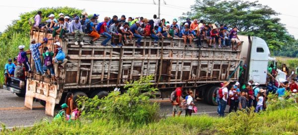
“However, these are not routes of mass use. They are not the most common. The massive flow of smuggled migrants entering Mexico continues to be by land. Once they enter Mexico the majority follow the route in trailers or caravans of compact vehicles that are the only ones that offer them the service,” says Figueroa.
Figueroa explains that in a clear violation of the law, public transport drivers have assumed a role that doesn’t correspond to them, since they ask for immigration identification from bus riders. “There are no laws regarding this, nevertheless there are agreements between carriers and the authorities to deny service to migrants unless they carry a document authorizing them to travel through Mexico. This exposes migrants to additional problems, such as accidents and other dangers,” Figueroa says.