Cuba Weather Experts on TS Karen
By Circles Robinson
HAVANA TIMES — Tropical Storm Karen continues to gain in intensity as it heads up the Gulf of Mexico en route for a possible landing somewhere between Louisiana and Alabama by late Saturday or early Sunday.
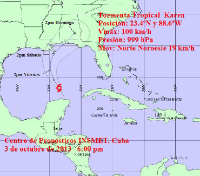
The Cuban Weather Service (INSMET) reports that the storm could reach hurricane strength sometime Friday. It currently packs 65 M/ph maximum sustained winds (100 K/ph) and is moving at a speed of 12 M/ph (19 K/ph) on a north-northwest path.
While Cuba is not in the direct route of TS Karen, heavy rains are expected in far western Pinar del Rio province and the Isle of Youth and some precipitation is also predicted for Havana.
At 6:00 p.m. EST, the center of Karen was located by INSMET at 465 miles south-southeast of the mouth of the Mississippi River along the US Gulf Coast.
INSMET will issue a new report on TS Karen at 6:00 a.m. local time (EST) on Friday.
Meanwhile the National Hurricane Center (NHC) in Miami has put out a Hurricane Watch for Grande Isle, Louisiana to Destin, Florida and a tropical storm warning from Grand Isle to the mouth of the Pearl River.
A tropical storm watch is also in effect for Metropolitan New Orleans, Lake Maurepas, Lake Pontchartrain, and Destin to Indian Pass, Florida.
According to the NHC, A hurricane watch means that hurricane conditions are possible within the watch area and is usually issued 48 hours before the first occurrence of tropical storm force winds.
A tropical storm warning means that tropical storm conditions are expected somewhere in the warning area within 36 hours. A tropical storm watch says the same but in an estimated 48 hours.