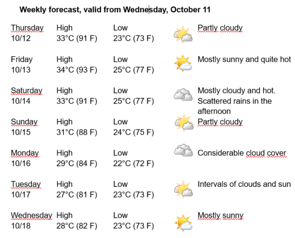
Havana Weather for October 12-18

Slight drop in temperatures in Havana…
By Adrian Fuentes
HAVANA TIMES – A humid flow from the south in the low and middle levels of the atmosphere continues to generate unstable conditions over the western half of the country, where cloudy weather has predominated with some rains, mainly in the first part of the day. Cloudy weather continues over much of the country, although scattered rain persisted over the capital on Wednesday.
A warm front extends from the western Atlantic to central Florida and near Tampa, continuing westward over the northwestern Gulf of Mexico. A trough extends from the low area of the front towards the south-southwest. According to the forecast, the low pressure and front will move from northeast to east reaching the NE Gulf this afternoon and inland in northern of Florida tonight.
High pressure across the Atlantic will increase modestly into the eastern Gulf on Friday until early Saturday, before the next cold front moves into the northwest Gulf on Saturday morning extending on the entire basin by Sunday night. With these conditions we will have partially cloudy days over Havana from the end of the morning, with a slight drop in temperatures starting on Sunday.
The winds will be mainly from the south, with speeds between 15 and 30 km/h. The relative humidity will range from 60-85%. The high temperatures will be between 27 and 34ºC (81 and 93 F) and the lows between 22 and 26ºC (72 and 79 F). The sea surface temperature will be 29ºC (84 F).
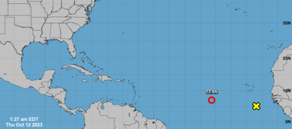
Tropical Depression Sean continues to move in the tropical eastern Atlantic with very little change in organization and intensity. It maintains maximum sustained winds of 65 kilometers per hour, with higher gusts and a minimum central pressure of 1006 hPa. This system continues moving west-northwest at 20 kilometers per hour. In the next 12 to 24 hours, the tropical storm will continue moving with a similar course and speed over the open waters of the eastern Atlantic, with very little change in its organization and intensity. This organism does not represent a danger to Cuba, it is only of interest for navigation in the area.
In the rest of the area of the Atlantic Ocean, Caribbean Sea and Gulf of Mexico, tropical cyclonic development is not expected in the next 12 to 24 hours.