Hurricane Maria Takes Aim at the Caribbean
Too early to tell if it will effect Cuba or Florida
By Circles Robinson
HAVANA TIMES – Several hurricane warnings and watches are in effect for the Eastern Caribbean Islands as hurricane Maria churns west and is expected to pass over or near several small countries starting Monday afternoon. Some of the same islands suffered considerable damage from hurricane Irma.
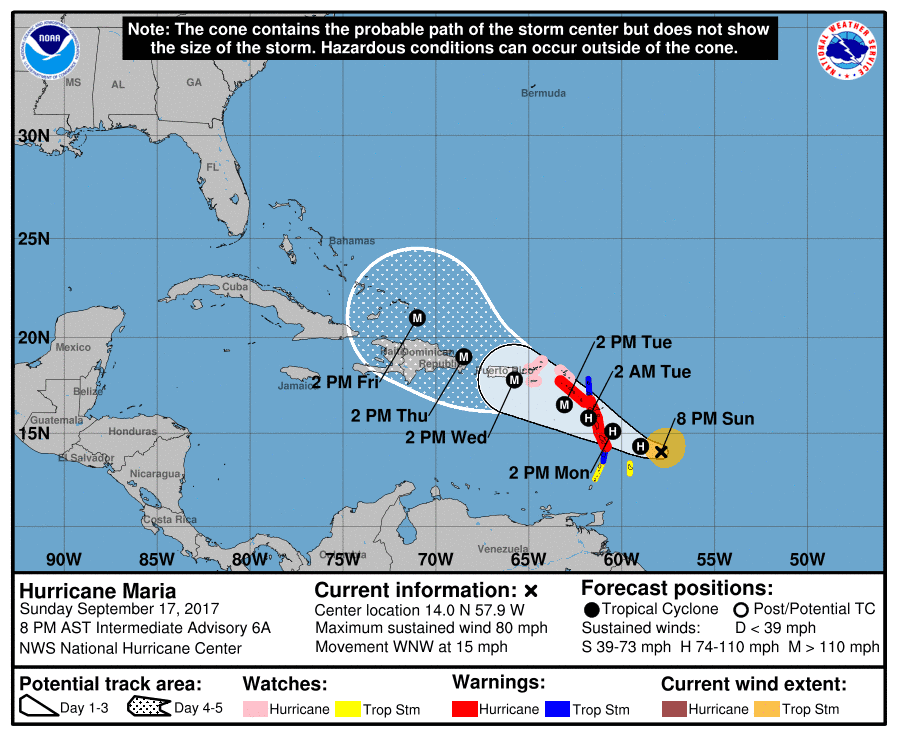
At 8 PM on Sunday, Maria packs 80 mph (130 km/h) winds. The center was located by the National Hurricane Center (NHC) at 125 miles (200 kms) east-northeast of Barbados and 255 miles (410 kms) east-southeast of Dominica.
The hurricane is currently moving west-northwest at a speed of 15 mph (24 km/h). Maria is expected to strengthen during the next 48 hours becoming a major hurricane with winds of at least 110 mph (180 km/h) by sometime Tuesday.
On Sunday night the NHC projection cone currently has Maria passing on or near Puerto Rico on Wednesday and moving just north of the Dominican Republic on Thursday. How the storm will move from there and whether it will effect Cuba and possibly Florida will be the subject of reports in the coming days.
Current hurricane force winds extend outward 15 miles (25 kms) from the center and tropical storm force winds 105 miles (165 kms). The minimum central pressure has been dropping rapidly and is now at 982 millibars.
WATCHES AND WARNINGS from the National Hurricane Center
SUMMARY OF WATCHES AND WARNINGS IN EFFECT:
A Hurricane Warning is in effect for…
* Guadeloupe
* Dominica
* St. Kitts, Nevis, and Montserrat
* Martinique
A Tropical Storm Warning is in effect for…
* Antigua and Barbuda
* Saba and St. Eustatius
* St. Lucia
A Hurricane Watch is in effect for…
* U.S. Virgin Islands
* British Virgin Islands
* Saba and St. Eustatius
* St. Maarten
* St. Martin and St. Barthelemy
* Anguilla
A Tropical Storm Watch is in effect for…
* Barbados
* St. Vincent and the Grenadines
A Hurricane Warning means that hurricane conditions are expected
somewhere within the warning area. A warning is typically issued
36 hours before the anticipated first occurrence of tropical-storm-
force winds, conditions that make outside preparations difficult or
dangerous. Preparations to protect life and property should be
rushed to completion.
A Tropical Storm Warning means that tropical storm conditions are
expected somewhere within the warning area within 36 hours.
A Hurricane Watch means that hurricane conditions are possible
within the watch area. A watch is typically issued 48 hours
before the anticipated first occurrence of tropical-storm-force
winds, conditions that make outside preparations difficult or
dangerous.
A Tropical Storm Watch means that tropical storm conditions are
possible within the watch area, generally within 48 hours.
HAZARDS AFFECTING LAND
———————-
WIND: Hurricane conditions are first expected within portions of
the Leeward Islands by Monday night, with tropical storm conditions
beginning on Monday. Hurricane conditions are possible within the
hurricane watch area by Tuesday, with tropical storm conditions
possible Monday night. Tropical storm conditions are possible in
the tropical storm watch area Monday or Monday night.
STORM SURGE: A dangerous storm surge accompanied by large and
destructive waves will raise water levels by as much as 4 to 6 feet
above normal tide levels near where the center of Maria moves
across the Leeward Islands.
RAINFALL: Maria is expected to produce total rain accumulations of
6 to 12 inches with isolated maximum amounts of 20 inches across the
Leeward Islands, including Puerto Rico and the U.S. and British
Virgin Islands, through Wednesday night. Maria is also expected to
produce total rain accumulations of 2 to 4 inches for the northern
and central Windward Islands. In all the above areas, these
rainfall amounts could cause life-threatening flash floods and
mudslides.
SURF: Swells generated by Maria are affecting the Lesser Antilles.
These swells are likely to cause life-threatening surf and rip
current conditions. Please consult products from your local
weather office.