Paloma Zeros in on Camaguey, Cuba
By Circles Robinson
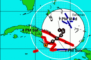
 HAVANA TIMES, Nov. 8.- It’s no longer a question of whether Hurricane Paloma is going to smash into Central-Eastern Cuba, it’s just a matter of hours.
Cuba’s top weather expert, Jose Rubiera, told a national radio and TV audience at 4:00 EST that the Category 4 hurricane is now expected to hit land on the south coast of Camaguey province in the early evening.
The projected place of entrance of the center is near Santa Cruz del Sur, locale of a major hurricane back 1932.
Rubiera noted that hurricane or tropical storm force winds will be felt in an area extending to Ciego de Avila, Camaguey, Las Tunas and Granma province.
Hurricane Paloma currently packs winds of 145 MPH (230 KPH) and for the studious on hurricanes; it has a minimum central pressure of 950 millibars. It’s currently moving on a northeastwardly path at 10 MPH.
At 3:00 p.m. the Cuban Meteorology Institute located the center of Hurricane Paloma at 43 miles (70 kilometers) southwest of Santa Cruz del Sur, Camaguey.
The highly productive agricultural region threatened by Paloma was also hard hit two months ago by Hurricane Ike.
A subsequent major effort there at replanting short-cycle crops to meet the country’s food needs stands to be lost to the winds, rain and subsequent flooding, dealing a blow to the nation’s recovery effort.
Rains associated with Hurricane Paloma continue in a wide area from Sancti Spiritus to Granma and Holguin provinces, with over 8 inches possible in some areas.
Coastal flooding is also considered a danger with the sea level expected to rise from 3 to 5 meters in affected areas. Rubiera said that if the mouth of the Cauto River is blocked by the effects of the wind, flooding could be intense in a large area of the river basin
More news on the development of Hurricane Paloma will be broadcast on the The Round Table program beginning at 6:00 EST.


