Tropical Storm Iota Threatens Nicaragua and Honduras
The tropical storm is expected to turn into a hurricane before it hits Nicaragua this Monday or early Tuesday
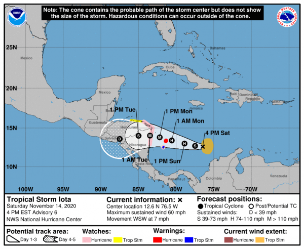
HAVANA TIMES – The US National Hurricane Center (NHC) reported today the formation of tropical storm Iota in the central Caribbean. It is forecast to become a hurricane before it approaches Nicaragua and Honduras, starting Sunday.
Nicaraguan authorities reported Saturday they expect Iota to reach land sometime Monday in the extreme northeast of the country. Furthermore, they noted it probably “will reach major hurricane intensity” and impact in the same area that 11 days ago was affected by the destructive hurricane Eta, which left thousands of victims. It also strongly affected Honduras and Guatemala before leaving a trail in Florida.
The storm may hit close to where Eta landed
“The storm is expected to approach Cabo Gracias a Dios, between the southeastern tip of Honduras and the extreme northeast of Nicaragua. A strengthened Iola should reach the coast by Monday afternoon or evening,” indicated the Nicaraguan Institute of Territorial Studies. (Ineter).
Ineter explained, however, that “due to its distance still to travel there could be alterations in the course as this system continues to advance towards the west”. There should be more certainty in the coming hours “as to its entry route and final intensity”.
The NHC had previously warned Honduras and Nicaragua to be vigilant for the development of downpours and thunderstorms associated with a broad low-pressure system over the Caribbean.
At 4:00 p.m. (ET) Iota’s center is about 375 miles (about 600 km) south of Kingston (Jamaica) and 480 miles (770 kms) east-southeast of Cabo Gracias a Dios on the border between Honduras and Nicaragua. It packs maximum sustained winds of 60 miles per hour (95 km/h), reports the NHC.
The storm is moving in a west-southwest direction at 7 miles per hour (11 km/h). Its minimum central pressure is 995 hectoPascal.
Strengthening rapidly
On the NHC forecast track, the system will traverse the central Caribbean Sea over the weekend, becoming a hurricane. It will approach the coasts of Nicaragua and northeastern Honduras on Monday afternoon / evening.
The NHC issued a hurricane watch for the east coast of Nicaragua from the Honduran border to Sandy Bay Sirpi. Likewise, for the northeast coast of Honduras from Punta Patuca to the border with Nicaragua.
A tropical storm warning is in effect for the Islands of San Andres and Providencia.
The Iota weather system is also expected to produce rain in northern Colombia, Panama, Costa Rica, Jamaica and southern Haiti through this coming Wednesday.
In Central America, the system has the potential to produce 20 to 30 inches (508 to 762 mm) of rain. This can occur especially in northern Nicaragua and Honduras, where significant flash floods, river overflows and landslides could occur.