Tropical Storm Laura in Route to Cuba
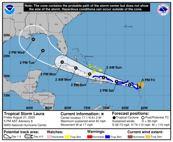
HAVANA TIMES – Tropical Storm Laura approaches the north of the eastern Caribbean on Friday evening. It is then projected to head for Puerto Rico, the Dominican Republic, Haiti and possibly Cuba. The storm is moving quite fast and could reach Guantanamo and Holguin by Sunday afternoon.
At 6:00 PM (ET) on Friday, the center of the storm was located by the Cuban weather service (Insmet) at around 65 kilometers east of Antigua. Its maximum sustained winds are currently 75 km/h with stronger gusts. The storm is moving west at 28 km/h.
Insmet notes that the intensity and path of Laura are still uncertain. The weather experts warn that as it approaches eastern Cuba there will be a gradual climate worsening starting on Sunday. They say the conditions will include cloud cover, rains, strong winds and a sea surge depending on the storm’s future evolution.
Meanwhile, the National Hurricane Center in Miami says the storm could reach Havana in less than 72 hours. (See their projection cone above,)
After Cuba, Laura is currently mapped to go straight towards New Orleans, possibly as a hurricane by Wednesday.