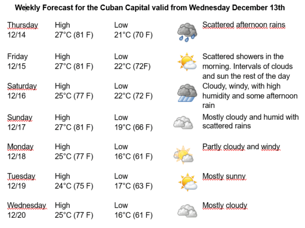
Havana Weather for December 14-20

Cloudy and rainy in areas of the northwestern coast…
By Adrian Fuentes
HAVANA TIMES – During the last 24 hours, numerous showers, rain, and thunderstorms have been reported in the western region, becoming strong and intense in some locations on the northern coast, mainly in Havana. The network of stations of the Institute of Meteorology and the rain gauges of the Institute of Hydraulic Resources reported significant accumulations greater than 100 millimeters in 16 locations, of which three exceed 200 millimeters.
These precipitations have been related to the instability generated by the retreat of the fifth cold front of the winter season over the west of the country, as well as local factors and high humidity.
Winter conditions are expected in Havana over the next few days, with a slight decrease in the low temperatures starting on Sunday. The winds will be mainly from the northeast to the east, with speeds between 20 and 35 kilometers per hour. The relative humidity will range between 60% and 90%. High temperatures will be between 24 and 27ºC (75 and 81 F) and the lows between 16 and 22ºC (61 and 72 F). The sea surface temperature will be 26ºC (79 F).
Starting on Saturday the 16th, an increase in the occurrence of precipitation is expected, which may become strong and locally intense in the western region of Cuba. The formation of severe weather is likely, with possible hail and strong winds in areas of showers and rain. From the early hours of Sunday the 17th, strong swells with waves of 2.5 to 4 meters high could be reaching the northern coast of western Cuba, and generating coastal flooding in low areas including the Havana seawall.