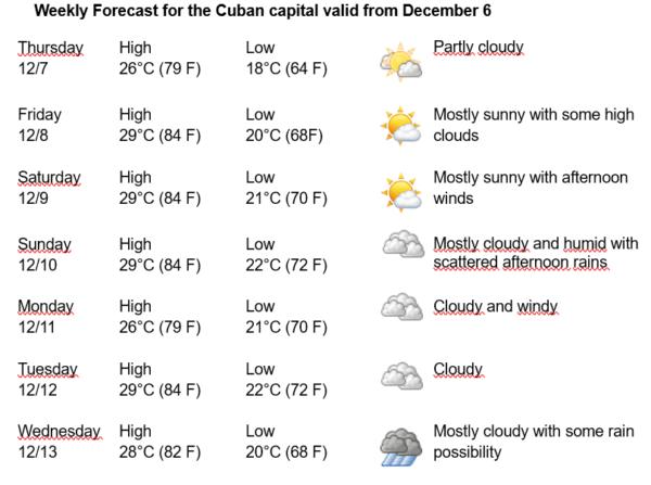
Havana Weather for December 7-13

Cool mornings for the next week in the Cuban capital…
By Adrian Fuentes
HAVANA TIMES – A cold front is passing through the central region of Cuba, extended from an extra tropical low located in the vicinity of Bermuda. This system is very weak in its southern portion, represented as a thin band of low clouds, which is allowing the high pressure center to overflow it, imposing a mass of dry air in much of the system national territory. This situation will continue to impose stable conditions in much of the country, although with the advance of the frontal band towards the east over the center and east of the country, isolated showers may occur towards the north of these regions.
With the influence of this new air mass, which is also colder, the high temperatures in the coming days will be between 26 and 29ºC (79 and 84 F) in the western half of the country, with the lows between 18 and 22ºC (64 and 72 F). The winds will be mainly from the east-northeast with speeds between 15 and 25 kilometers per hour, with higher gusts in areas of the north coast. The relative humidity will range between 40% and 70%. The sea surface temperature will be 26ºC (79 F).
The cold front extending from northwest Cuba continues as a stationary front until a weak low pressure of 1017 hPa in the south-central Bay of Campeche. The front will move southeast and enter the northwest Caribbean late this morning, accompanied by moderate winds. Generally strong northerly winds are expected to persist along the coastal zone as they expand across the Bay of Campeche this afternoon before easing tonight. High pressure behind the front will move east into the Atlantic Thursday night, inducing a moderate return flow across most of the basin Friday into Saturday, ahead of the next cold front forecast to enter the northwest Gulf of Mexico Saturday night. It is likely that there will be strong winds (in localities almost hurricane-force) behind the front, and it is possible that there will be hurricane-force winds in the southwest of the Gulf of Mexico, imposing moderate waves on the Cuban capital, with danger for small vessels.
A large swell is expected to continue across tropical North Atlantic waters east of the Lesser Antilles through Thursday, while a new cold front will move into the northwest Caribbean and extend from the northern coast of Hispaniola to the Gulf of Honduras on Thursday night, where it will remain almost stationary until Saturday. Locally strong northeasterly winds are expected to develop in the vicinity of the front across the Yucatán Channel near Cuba.
Once the cold fronts merge, which is expected to be within 30 to 36 hours, gale-force winds from the west to northwest and rough seas are forecast to develop for approximately 6 hours. These conditions will impose waves on the entire northern coast of Havana, increasing to swells in the afternoon. There will be little waves along the entire southern coast.