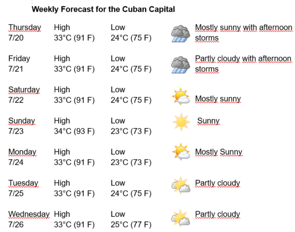
Havana Weather for July 20-26

Hot afternoons and isolated rains in the Cuban capital
By Adrian Fuentes
HAVANA TIMES – Cuba is under the weak influence of subtropical high pressure, which continues to impose weak variable winds over the entire national territory. Partly cloudy days are expected from the end of the morning, becoming cloudy in the afternoon in the western region, with a high probability of rain, showers, and electrical storms over Havana, which can be strong in some locations. The winds will be mainly from the east-northeast, with speeds between 15 and 25 km/h. The relative humidity will be between 75% and 95%. The high temperatures will be 33 and 34ºC (91 and 93 F) and the lows between 23 and 25ºC (73 and 77 F). The sea surface temperature will be 30ºC (86 F).
A tropical wave travels through the western Caribbean seas, while in the upper levels of the troposphere a higher low is also located in this part of the Caribbean. The combination of these systems is stimulating convective clouds over the Straits of Florida and in the seas to the south of the west of Cuba, which will last until Friday, with the occurrence of isolated showers and rains, which will become numerous in the afternoon and even strong in some locations.
The upper-level center of cyclonic circulation will have associated isolated moderate to heavy rainfall, in addition to strong east-northeast winds. Swells are expected on the Havana coast, with possible flooding in the low lying coastal areas of the capital.
In the rest of the area of the Atlantic Ocean, the Caribbean Sea and the Gulf of Mexico, tropical cyclone development is not expected in the next 12 to 24 hours.