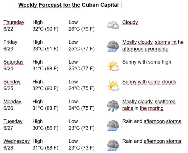
Havana Weather for June 22-28

Another hot week in Havana…
By Adrian Fuentes
HAVANA TIMES – Cuba and adjacent seas remain on the periphery of the influence of tropical high pressure, which maintains a regime of weak variable winds over Havana. In the upper levels of the atmosphere, an upper low is located in the northwest of the Caribbean Sea, extending a trough over the western part of the country, while low moisture content prevails at medium and low levels.
This situation, together with afternoon instability conditions, related to the daytime warming and local factors, will be stimulating isolated rains in the afternoon in areas of the north coast of the western region, which will last until night.
For the next week the winds will be mainly from the east to the northeast, with speeds between 10 and 20 km/h. The relative humidity will range between 60% and 80%. The high temperatures will be between 30 and 33ºC (86 and 91 F) and the lows between 23 and 26ºC (73 and 79 F). The sea surface temperature will be 28ºC (82 F).
Meanwhile, Tropical Storm Bret was about 408 km east of Barbados at 11 AM on Wednesday. It moves west at 22 km/h with an estimated central minimum pressure of 1001 mb. The maximum sustained wind speed is 92 km/h with higher gusts. Scattered to heavy moderate convection is observed and Bret is expected to continue moving westward over the next several days. On the forecast track, the center of Bret is expected to approach the Lesser Antilles on Thursday, move across the Lesser Antilles on Thursday night, and then move west across the eastern and central Caribbean between Friday and Saturday, dissipating in the early hours of Sunday.