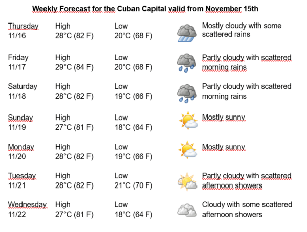
Havana Weather for November 16-22

Cloudy, rain and thunderstorms…
By Adrian Fuentes
HAVANA TIMES – Over Cuba, high clouds predominate that do not generate precipitation, however, some rains occurred in the early morning hours on Wednesday in areas of the northern coast, related to the presence of an almost stationary front that extends from the Atlantic to the Gulf of Mexico, crossing the Bahamas and the north of the Cuban archipelago.
On the other hand, a low pressure center located over the central-western Caribbean Sea extends a trough east of Nicaragua and Honduras, to the Yucatan Channel and another to the south of Jamaica. The combination of these systems causes an increase in relative humidity over the geographic area, encouraging cloudiness and precipitation. In the last 24 hours, numerous rains have been reported in Havana, and it is expected that cloudiness will gradually increase, with showers, rains, and thunderstorms during the next few days.
The winds will be mainly from the northeast with speeds between 15 and 30 kilometers per hour, with higher gusts. The relative humidity will be between 80% and 100%. The high temperatures will be between 27 and 29ºC (81 and 84 F) and the lows between 18 and 21ºC (64 and 70 F). The sea surface temperature will be 28ºC (82 F).
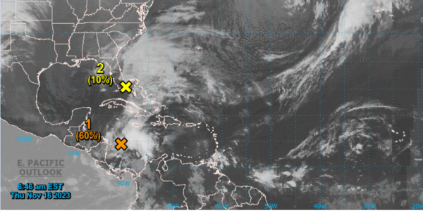
1. Southwestern Caribbean Sea:
A broad area of low pressure over the southwestern Caribbean Sea is producing a large area of disorganized showers and thunderstorms. Environmental conditions are unfavorable for the development of this system over the next few days, and a tropical depression could form this weekend as the system moves northeastward across the western and central Caribbean Sea. Regardless of its development, this system is expected to produce heavy rainfall that could cause flash flooding and landslides on parts of the Caribbean coast of Central America and the Greater Antilles this weekend.
2. Southeast coast of the United States:
A non-tropical area of low pressure is forming near southern Florida along a frontal boundary. This system is forecast to move rapidly northeastward across the Bahamas and off the US East Coast over the weekend. Although it appears unlikely to become a tropical cyclone, this system is expected to produce gusty winds and heavy rain across parts of southern Florida, the Florida Keys, and the Bahamas over the next few days.
In the rest of the area of the Atlantic Ocean, Caribbean Sea and Gulf of Mexico, tropical cyclone development is not expected during the next 12 to 24 hours.