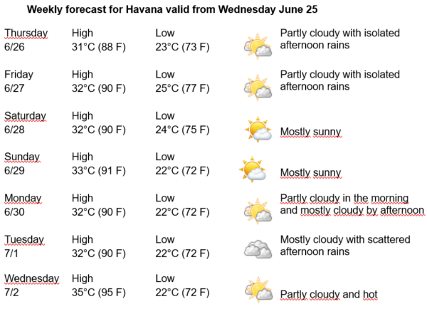
Havana Weather for June 26 to July 2

Hot and some rain…
By Adrian Fuentes
HAVANA TIMES – Over Cuba and adjacent seas, oceanic high-pressure systems continue to dominate. Two tropical waves are currently moving across the Caribbean Sea. The first is located south of western Cuba, and the second is over Haiti, which will move south of the island’s eastern tip by the afternoon. An upper-level low is located northeast of the Bahamas and extends a trough down to the north-central region of Cuba. At the surface, this system appears as an inverted trough over the Bahamas, stretching toward the north-central Cuban coast.
These systems, in combination with local-scale factors and afternoon atmospheric instability caused by intense daytime heating typical of this time of year, will encourage the occurrence of isolated showers along the northern coast and inland areas of the capital. In the rest of Havana, some showers, rain, and thunderstorms will occur, with higher frequency in specific inland and southern locations, possibly continuing into the evening hours.
In the coming days, it will be partly cloudy at dawn in inland and southern areas of Havana, while the rest of the capital will have little cloud cover. By late morning, cloudiness will increase, spreading in the afternoon toward inland and northern coastal zones, bringing some showers, rain, and thunderstorms that may extend into the night.
Winds will be from the east to northeast at speeds between 10 and 25 kilometers per hour (6 to 15 mph). Relative humidity will range from 70% to 85%. Highs will range between 31 and 35°C (88 to 95°F) and lows between 22 and 25°C (72 to 77°F). Sea surface temperature will be 28°C (82°F).
No tropical cyclone development is expected in the Atlantic Ocean, Caribbean Sea, or Gulf of Mexico in the next 12 to 24 hours.