Havana Weather for March 16-22

Showers in the west after the arrival of a new cold front…
By Adrian Fuentes
HAVANA TIMES – A stationary front extends west-southwest from the central Bahamas across the Straits of Florida, just northwest of the Yucatan Peninsula. The stationary front is being reinforced by a surge of moderate winds from the NE, which should transform it back into a cold front by Wednesday afternoon, continuing its southward motion tonight. It will develop across the western Gulf tonight, with the flow turning light to strong early Thursday, spreading across the entire gulf Thursday night, before the onset of fresh cold. This second cold front will enter the northwestern gulf on Friday morning. Strong N winds are expected behind the front.
A shallow ridge associated with a high pressure center in the central Atlantic continues to maintain a trade wind regime over Cuban territory. A shallow trough over eastern Cuba and Jamaica is generating scattered showers and isolated thunderstorms in the east and center of the country, with moderate and locally strong easterly winds.
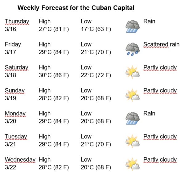
Scattered showers and thunderstorms are forecast for the rest of the week, increasing the chances of rain and wind speeds on Friday afternoon, after the arrival of the new frontal system. The winds will be mainly from the North, with speeds between 15 and 30 km/h. The relative humidity will range between 70% and 90%. The High temperatures will be between 28 and 30ºC (82 and 86 F) and the Lows between 18 and 22ºC (64 and 72 F). The sea surface temperature will be 26ºC (79 F).