Tropical Storm Ian May Pose a Serious Threat to Western Cuba
By Circles Robinson
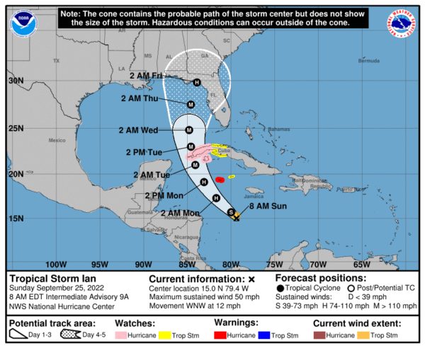
HAVANA TIMES – As Cubans go to the polls today to approve or reject a new Family Code, weather watchers and civil defense authorities are concerned about Tropical Storm Ian as it churns in the central Caribbean and is expected to turn north throughout Sunday.
With nothing but open seas on its path, the tilt north of the weather system will most likely determine the extent of the threat. Grand Cayman Island is already under a hurricane warning.
The western Cuban provinces of Pinar del Rio, Artemisa and the Isla de la Juventud are on a Hurricane Watch. Likewise, the provinces of La Habana, Mayabeque, and Matanzas are on Tropical Storm watch, reports the National Hurricane Center (NHC).
At 6 AM on Sunday morning the Cuban Weather Institute (Insmet) said the center of TS Ian was moving west-northwest at a speed of 12 mph (19 kph) with maximum sustained winds of 50 mph (85 kph). Both the Cuban weather service and the NHC see the storm increasing intensity rapidly during the coming 12 to 24 hours.
The current forecast sees the center of Ian with hurricane strength by early Monday and possibly a major hurricane by Tuesday before approaching western Cuba or the Yucatan channel between Mexico and far western Cuba.
We will keep you informed, the path and intensity of the storm should be clearer by late Sunday or early Monday.