TS Laura Churns South of Central Cuba
HAVANA TIMES – During Sunday night the center of tropical storm Laura turned towards the south of the island. At this time on Monday morning it transits in the sea to the south of Sancti Spritus province, which includes Trinidad, in Central Cuba.
The winds in the eastern provinces of Guantanamo and Santiago de Cuba have lessened in intensity while rains continue. Here is the latest report from the Cuban Forecast Center (Insmet), which came out at 9:00 AM Cuban time (ET).
Cuban Forecast Center (Insmet)
August 24, 2020. Time: 9:00 am.
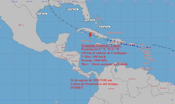
TROPICAL STORM LAURA
Laura moves to the south of the central region of Cuba
The center of tropical storm Laura is in the sea to the south of the central region of Cuba, over the Jardines de la Reina archipelago. The heavy cloud cover and rains continue to affect the eastern provinces, which will extend over the next few hours to Ciego de Avila, Sancti Spiritus and Cienfuegos. The rain can be intense in some locations, mainly in mountainous areas.
The winds will increase until reaching speeds between 65 and 80 kilometers per hour and higher gusts that could exceed 100 kilometers per hour. The conditions will gradually spread from this morning to the rest of the central region. In Guantánamo and Santiago de Cuba, the force of the winds will continue to decrease, as will the storm surge. Although in areas of showers and thunderstorms strong gusts can still be registered and high waves on the coasts.
Strong swells with coastal flooding will continue on the north coast from Holguín to Ciego de Ávila, which will spread to the rest of the north central coast in the course of the morning. Light to moderate flooding will be generated on the southern coast of Las Tunas and Camagüey in the coming hours, and then the south central coast.
The cloudy areas with heavier rains are located in the southern semicircle of this system, extending to the seas adjacent to Jamaica. Some areas of heavy rainfall persist over Santiago de Cuba and Granma.
At nine in the morning on Monday, Laura’s center was estimated at 21.0 degrees North latitude and 79.4 degrees West longitude. A position that places it at 135 kilometers southeast of the city of Cienfuegos and 275 kilometers southeast of Punta Gorda, in the Zapata peninsula of Matanzas.
The tropical storm has continued to move rapidly west-northwest, at a rate of 33 kilometers per hour. Its maximum sustained winds remain at 100 km/h, with higher gusts. The central pressure is 1000 milibar.
Tropical storm Laura is expected to continue a similar course and movement speed. By noon the center should be located to the south of Cienfuegos.
It is predicted that in the next few hours the storm may gain in organization and intensity, as its center moves over warm waters.
The showers and rains associated with the tropical storm continue over the eastern provinces. The most significant accumulated rainfall were: Valle del Caujerí, Guantanamo with 130 millimeters and 122.2 millimeters in the city of Santiago de Cuba and Jamal in Guantánamo with 120 millimeters.
At the weather station of Cabo Cruz, Granma, a gust of wind from the south was recorded that reached 104 kilometers per hour at 4 AM, with sustained winds of 80 kilometers per hour.
The next advisory on tropical storm Laura will be issued at noon today.