What’s Happening with Tropical Storm Fiona?
By Circles Robinson
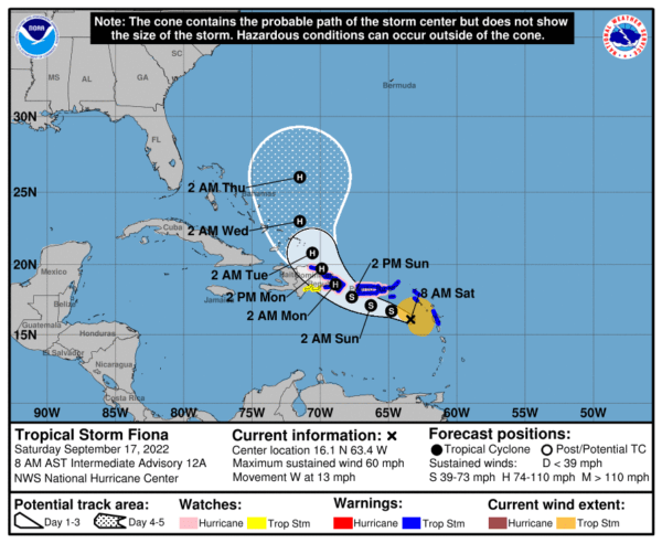
HAVANA TIMES – The center of Tropical Storm Fiona has passed the Leeward Islands and is on a track that would take it south of Puerto Rico en route to the Dominican Republic. The weather system strengthened a little over night. The maximum sustained winds are now 60 mph (96.5 kph) and the weather system is moving west-northwest at 13 mph (21 kph).
As predicted in recent days, the storm is not expected to have any direct affect on Cuba. Nonetheless, history has shown that it’s better to be prepared than caught off guard if the track suddenly changes. We can be sure that Cuban civil defense authorities are paying close watch.
At 8 a.m. (ET) on Saturday the National Hurricane Center is forecasting that Fiona will gain in strength, possibly becoming a hurricane, after passing south of Puerto Rico and before a possible landing somewhere on the east of the Dominican Republic which has an alert in place on both its south and north coasts.
After the Dominican Republic the current track sees Fiona turning sharply north.
For those readers wanting more detail, the following is the current discussion from the National Hurricane Center website.
Tropical Storm Fiona Discussion
National Hurricane Center Miami FL. 500 AM AST Sat Sep 17 2022
While the center of Fiona is moving westward over the northeastern Caribbean Sea, the strongest winds and heaviest rains associated with the storm are still displaced to the east of the center by some westerly shear. Tropical storm conditions are ongoing over portions of the Leeward Islands. Earlier data from an Air Force Hurricane Hunter aircraft indicated the minimum pressure had fallen slightly to 1000 mb, but the aircraft winds on the final passes did not show signs of additional strengthening. A blend of the latest satellite intensity estimates and the earlier aircraft data support an initial intensity of 50 kt for this advisory. NOAA and Air Force Hurricane Hunter aircraft are scheduled to investigate Fiona this morning.
The center of Fiona was adjusted a bit south of the previous track based on aircraft and radar data, and the initial motion is westward at 275/11 kt. A westward to west-northwestward motion is expected through Sunday, which brings the center of Fiona near or just south of the Virgin Islands and Puerto Rico and toward the eastern portion of the Dominican Republic. Although some of the track guidance shifted a bit right this cycle, the adjusted initial position resulted in little net change to the NHC track forecast with regard to Fiona’s closest approach to Puerto Rico. However, it is noted that the latest track forecast is somewhat slower than the previous one based on the latest guidance trends. After passing near or over the Dominican Republic, a northwestward and northward turn is expected next week over the southwestern Atlantic. The forecast track at days 3-5 was nudged a bit eastward based on the consensus aids.
Fiona is expected to encounter slightly more favorable environmental conditions over the next 24-48 h. In particular, the westerly shear that has plagued Fiona for days is forecast to weaken, which could allow the cyclone’s structure to improve and become more vertically aligned. The latest intensity guidance is stronger than the previous cycle, and the NHC forecast has been adjusted upward during the first 36 h of the period. Fiona could be at or near hurricane force when it passes near Puerto Rico later this weekend, and a Hurricane Watch has been issued to account for this potential. If current trends continue, further increases to the intensity forecast may be necessary on future cycles. Some brief weakening is possible due to interaction with the mountainous terrain of Hispaniola, but re-strengthening seems likely once Fiona moves over the southwestern Atlantic next week. The NHC intensity forecast has been raised on days 3-5 in line with the latest consensus aids.
Key Messages:
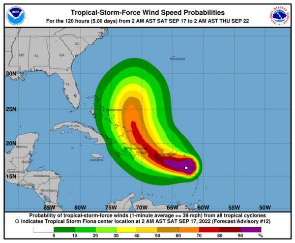
1. Tropical storm conditions will continue to affect portions of the Leeward Islands through this morning. Tropical storm conditions will reach the U.S. and British Virgin Islands this morning and spread westward across Puerto Rico later today and tonight. Fiona could be near hurricane strength as it moves near Puerto Rico late tonight and on Sunday, and a Hurricane Watch has been issued.
Additional watches or warnings could be required later today for portions of the Dominican Republic.
2. Heavy rains from Fiona will spread west to British and U.S. Virgin Islands and Puerto Rico today, the Dominican Republic Sunday, and the Turks and Caicos Monday night. This rainfall is likely to produce considerable flood impacts including flash and urban flooding, along with mudslides in areas of higher terrain, particularly in Puerto Rico.
3. Fiona is forecast to strengthen after moving across Hispaniola early next week, and interests in the Turks and Caicos Islands and southeastern Bahamas should continue to monitor forecasts for the storm.
Hopefully the next storm will head straight for Mar A Lago and totally destroy it. It would be so cute to watch Mar a Lago get sucked up by the roaring Atlantic.