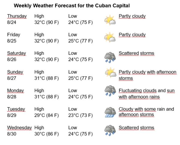
Havana Weather for August 24-30
Cyclonic activity continues in the Atlantic…
By Adrian Fuentes
HAVANA TIMES – In the last twenty-four hours, numerous rains have been recorded in much of the western part of the country, being isolated in areas of the capital. The rains were related to the presence of an upper low that moves to the north of the western and central regions, in combination with daytime warming and the arrival of low clouds in the flow from the northeast to the east.
The occasional showers generated by the moving low clouds to areas of the north coast are expected to continue over Havana, while the instability in the afternoon hours generated by the upper low and the strong daytime heating will bring some rains and electrical storms in towns in the interior and on the north coast.
The winds will be mainly from the northeast to the east, with speeds between 10 and 20 km/h. The relative humidity will range between 70% and 95%. The high temperatures will be between 29 and 32ºC (84 and 90 F) and the lows between 23 and 25ºC (73 and 77 F). The sea surface temperature will be 31ºC (88 F).
Tropical storm Franklin made landfall on Wednesday in the southern Dominican Republic. It was located at eight in the morning about 170 kilometers southwest of Santo Domingo. Its maximum sustained winds are 85 kilometers per hour, with higher gusts, and its central pressure had dropped to 1000 hPa. It is moving in a northerly direction at a rate of 17 kilometers per hour and in the next few hours it will turn north-northeast at a similar speed.
An area of low pressure centered several hundred kilometers to the east-northeast of the Leeward Islands, remnants of former Tropical Storm Emily, continues to produce a large area of disorganized showers and thunderstorms. Environmental conditions will become more favorable for this system to regenerate in the open waters of the subtropical Atlantic Ocean, and a tropical depression or tropical storm could form this week as the system moves northward.
On the other hand, a tropical wave several hundred kilometers west of the Cape Verde Islands is generating an area of showers and disorganized thunderstorms. Current environmental conditions are marginally favorable for slow tropical cyclone development over the next week as the system moves west-northwestward over the eastern-central tropical Atlantic.
In the rest of the area of the Atlantic Ocean, the Caribbean Sea and the Gulf of Mexico, tropical cyclone development is not expected in the next 12 to 24 hours.