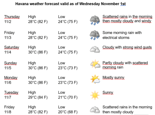
Havana Weather for November 2-8

Somewhat strong winds from the northeast, with isolated showers and rains in the capital…
By Adrian Fuentes
HAVANA TIMES – In the last 24 hours, some rains occurred in western Cuba, isolated in the center of the island and numerous in the eastern region. High migratory pressures influence the west, although a trough in the middle levels of the atmosphere located in the southeast of the Gulf of Mexico, together with local factors, stimulated convective instability, giving rise to isolated showers over the capital.
During the next few days, cloudy weather will predominate in Havana, with some showers and rains, which will become more numerous during the afternoon, mainly in areas of the northern coast. Somewhat strong winds will blow from the northeast, with speeds between 20 and 35 kilometers per hour, with higher gusts. The relative humidity will range from 70% to 95%. The high temperatures will be between 28 and 30ºC (82 and 86 F) and the lows between 20 and 24ºC (68 and 75 F). The sea surface temperature will be 28ºC (82 F).
Scattered showers and isolated thunderstorms are observed in the central Caribbean Sea in association with a weak tropical disturbance. Environmental conditions could become slightly more conducive to development in the next day or two, and a tropical depression could form as the system moves over the southwestern Caribbean Sea during the latter part of this week. Regardless of development, this system has the potential to produce heavy rain in parts of Central America later this week and over the weekend. Currently, the system has a low probability of tropical cyclone formation within 48 hours and a medium probability within 7 days.
A strong cold front extends from the Straits of Florida to the interior of the northeastern part of the Yucatan Peninsula. This cold front is forecast to extend from eastern Cuba to the Gulf of Honduras on Thursday morning, then stabilize and dissipate on Saturday. Winds and waves will begin to decrease today in the northwest Gulf and across much of the basin on Thursday. However, generally strong NE winds and rough seas will continue to affect the Havana coast until Friday, before decreasing on Saturday.
In the rest of the area of the Atlantic Ocean, Caribbean Sea and Gulf of Mexico, tropical cyclonic development is not expected in the next 12 to 24 hours.