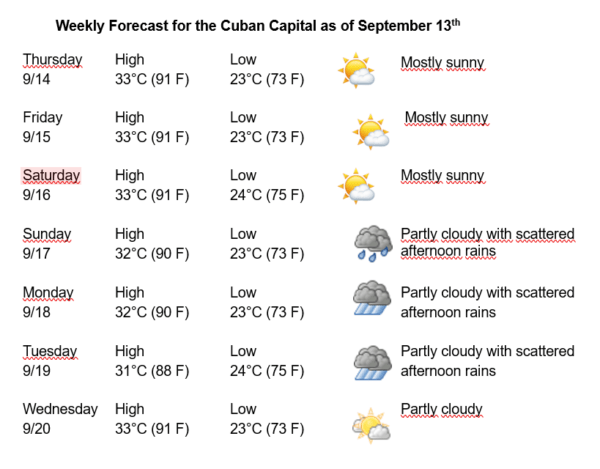
Havana Weather for September 14-20

Hot with scattered afternoon rains
By Adrian Fuentes
HAVANA TIMES – The next few days will begin with little cloudiness in much of the country. From the end of the morning, it will be partly cloudy, building up in the afternoon in locations on the northern coast of the central and eastern region with isolated showers and thunderstorms, which will be rare in the rest of the country. In Havana, no significant accumulations of precipitation have been reported in the last few hours, and these conditions are expected to continue for the next few days.
The winds will be mainly from the northeast, with speeds between 15 and 20 km/h. The relative humidity will range between 70-90%. The high temperatures will be between 31 and 33ºC (88 and 91 F) and the lows 23 and 24ºC (73 and 75 F). The sea surface temperature will be 30ºC (86 F).
Cuba and adjacent seas remain under the influence of high pressure, imposing northeasterly winds on the country in the west and center, while in the east they will be from northwest to north. Throughout the tropospheric column, stable conditions predominate over the national territory, although in the afternoon local factors and the daytime warming will stimulate isolated rainfall in areas of the central and eastern northern coast.
Monitoring continues of Hurricanes Lee and Margot, which are moving in the open waters of the Atlantic Ocean. Lee is located approximately 740 kilometers south-southwest of Bermuda and maintains maximum sustained winds of 185 kilometers per hour, with higher gusts, with a minimum pressure of 948 hPa, a category three hurricane on the Saffir Simpson scale. On the other hand, Margot is located approximately 1270 kilometers west southwest of the Azores. It has maximum sustained winds of 140 kilometers per hour, with higher gusts, making it a category 1 hurricane.
An area of low pressure located over the eastern tropical Atlantic Ocean continues to show disorganized shower and thunderstorm activity. This system may experience some development in the coming days and become a tropical depression as it moves over the central Atlantic.
In the rest of the area of the Atlantic Ocean, Caribbean Sea and Gulf of Mexico, tropical cyclone development is not expected in the next 12 to 24 hours.