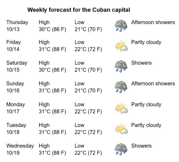
Havana Weather for October 13-19

Some afternoon showers
By Yanet Diaz
HAVANA TIMES – Tropical storm Karl is centered in the Gulf of Mexico, about 380 km north-northeast of Veracruz, Mexico, with a minimum central pressure of 1,002 mb and sustained winds of 92 km/h. Its current forecast indicates that it will move south-southeast, approaching the coast of Mexico this Friday. Therefore, this tropical system does not represent a threat to Cuba.
A weak cold front will transit over the Gulf of Mexico on Friday, becoming stationary near the Florida Straits and finally dissipating on Monday night. Later, a front of greater intensity is expected towards the middle of next week, which may cause some rain and intense winds from the north over Havana and western Cuba.
The days will be warm with some clouds from the morning, which will intensify from noon on with some chances of rain in the Cuban capital. The winds will be from the east and the northeast, with speeds between 15 and 30 km/h. Relative humidity will reach maximums of 95%. The high temperatures will be 30 and 31°C (86 and 88 F), while the lows at 21 and 22°C (70 and 72 F). The sea surface temperature will be 28°C (82 F).
Apart from Tropical Storm Karl, over the Gulf of Mexico, the Caribbean Sea and the Atlantic Ocean no new tropical cyclone formation is expected for the next 5 days.


