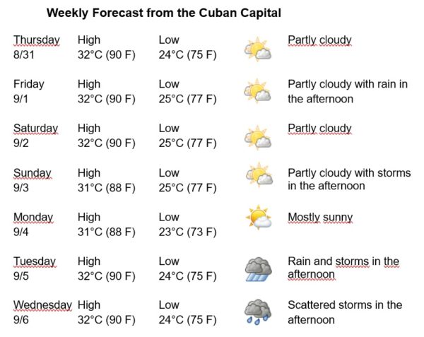
Havana Weather for August 31 to September 6

Warm Days and Isolated Rains Are Expected in the Afternoons
By Adrian Fuentes
HAVANA TIMES – After dumping considerable rain over far western Cuba, Hurricane Idalia made landfall in the US at 7:45 AM this Wednesday in northern Florida. Now over Georgia it has been moving north-northeast at the rate of 21 miles per hour. At 6 PM Cuba time the maximum winds are 70 mph.
In the last 24 hours, numerous rainfalls have been reported in Havana, which have been strong and intense in some locations. These rains are generated by an unstable flow from the southern region generated by the movement of Hurricane Idalia to the north of the country.
For the next week, warm days with very little change in temperatures are expected, while favorable conditions for rains over Havana will remain due to the persistence of this unstable and humid flow. The winds will be mainly from the northeast, with speeds between 10 and 25 km/h. The relative humidity will range between 60 and 90%. The high temperatures will be 31 and 32ºC (88 and 90 F) and the lows between 23 and 25ºC (73 and 77 F). The sea surface temperature will be 30ºC (86 F).
Hurricane Franklin has weakened to Category 2 on the Saffir Simpson scale, out of a maximum of five. It was located at 8:00 AM about 290 kilometers west-northwest of Bermuda. It has maximum winds of up to 175 kilometers per hour and continues moving northeast at 20 kilometers per hour over waters of the western Atlantic Ocean.
On the other hand, Tropical Depression number 11 of the current hurricane season, was located at five in the morning about 1,300 kilometers east-southeast of Bermuda. It maintains maximum sustained winds of 55 kph and moves east at only 2 kph.
An area of low pressure associated with a tropical wave is generating disorganized areas of rain and storms very close to the Cape Verde Islands in the eastern tropical Atlantic Ocean. Environmental conditions are favorable for the cyclonic development of this system as it moves slowly to the west-northwest over open waters of the Atlantic.
In the rest of the area of the Atlantic Ocean, the Caribbean Sea and the Gulf of Mexico, tropical cyclone development is not expected in the next 12 to 24 hours.